
Old and modern maps and plans of Vierville
Maps of the 16th / 17th centuries
The most remarkable are those of Mariette de la Pagerie
That of Bessin, exceptionally detailed, was never printed, only drawn around 1680
Look at the enlarged details of what will become 3 centuries later the Bessin and Omaha Beach
The original fits in a square of 35 to 40 cm on each side, the scale is imprecise, given the limited means of the time, especially for the measurement of longitudes.
Notice the uncultivated lands south of the coast between Vierville and Formigny, water and windmills, and all kinds of indications to discover and interpret.
The raz of the Percée is to be compared to recent soundings with lateral scanning sonars). See in particular the results from the data. See below the data from the Dassault Systemes surveys and their presentation by the SHOM (Maritime Hydrographic and Oceanographic Service)

Below to facilitate decryption, black and white reproductions, and by increasing the contrast

Below is the plan of the SHOM, from the surveys using modern sonars
We distinguish, superimposed, the bottoms and wrecks of the nautical charts, the underwater wrecks of the Mulberry port, (reinforced concrete debris or metal hull bottoms), and also the underwater reliefs of 4 rock bars which extend to the Northeast, which are visible when sea conditions allow and which are used by rock fish fishermen, amateurs or not.
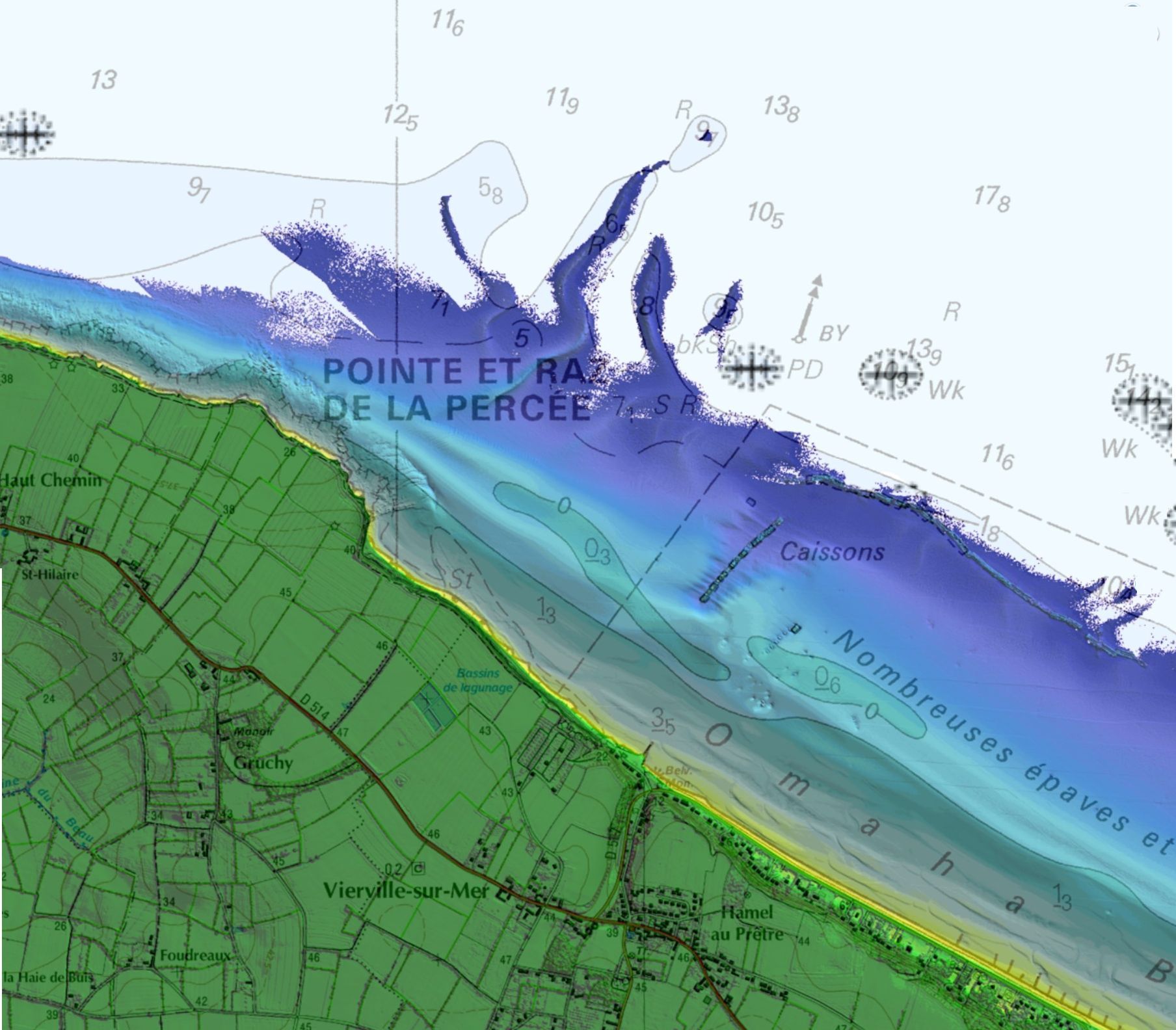
Trial of comparison of plans, in 1680 and currently

________________________________________________________________________
The main maps of Bessin drawn by Mariette
Illustration mentioned in the fund, but absent from this copy: CarteMariette-c1685-BessinO-7277x6895-H40cmL.jpg (document absent from this copy)
Bessin West map, version 1, c1885
Illustration mentioned in the background, but absent from this copy: CarteMariette-c1685-BessinE-7277x6895-H40cmL.jpg (document absent from this copy)
Bessin East map, version 1, c1685
Illustration mentioned in the fund, but absent from this copy: CarteMariette-c1690-BessinEetO-9930x4590-H40cmL.jpg (document absent from this copy)
Bestin East and West Map, version 2, c1890
The 2 elements were connected at an indefinite time, perhaps late
Other old cards

(details) Cenomano britanniae 1550

(details) Map of 1675, (Jean Petite) with the words "Vierville sur la mer" and "ancien port"

(details) Cartridge presenting the "particularities of the diocese"
See the transcript of these rather picturesque texts.
(details) Dedication of the card of
Jean Petite

(details) list of parish "patrons"


(details) Map of Mariette de la Pagerie, around 1689

Map of Christophe Tassin 1634


Map of Tassin 1634
18th century maps

Normandy 1754

Map of Vaugondy

This nautical chart was raised under the leadership of Captain Price, commanding the English forces in Saint-Marcouf. It specifies all the distances between the islands and the coast from St-Vaast to Vierville-sur-Mer


19th century maps

The cadastre of 1823, assembly plan

Detailed view of the quarter NO

Detailed view of the quarter NE

Detailed view of the quarter SO

Detailed view of the quarter SE


details Map of the borough of Bayeux, 1822. It includes several local roads, including those from Vierville to Formigny, Port and Grandcamp. (in its extensions, it also shows that the Isigny bridge exists, so the grand vey is no longer practiced)


(details Vierville area) Calvados 1877 to 1895,

Engraved perhaps by Rémy Hausermann (according to a specialist in old engravings, it could be that Rémy H. only modified it from 1877)
PM - There was a map, called the Ministry of the Interior, on the scale of 1/100,000. I miss the Vierville sheet.

(details) map of 1873, by Vuillemin


Department of Calvados 1835

(details) Calvados 1879


A map from 1878, notice the first houses on the beach

(details) Calvados 1900


Around 1855, an old map with the description of rivers and mills

(details) "Staff" card at 1/50000, enlargement of the one established at 1/80000 around 1839, and revised in 1910. It was the most detailed available in 1939

In 1944, the Allies established much more detailed maps, in contour lines and colors.
Below is the revision of 1866 (scale 1/80000)

(details) Extract map at 1/80000, revision of 1866


(details) in 1866 Grandcamp-Isigny

1944 military cards

Military card 1944, front and back with information on tides and currents. Approx. 1/7920

Military card 1944 at 1/12500

Military card 1944 to 1/25000

Military card 1944 to 1/50000
Recent maps and plans

Limits of the municipalities of the Intercom

Intercom and parish boundaries

Extract from the 1994 SHOM map

Road environment

Roads of Vierville


SCOT Bessin and its orientations


Land Use Plan, parts NO, NE, SO, SE (POS revised from 1995 and amended around 2007, in force on 1/9/2011)


Zoning plan of the PLU project (latest version of 1/9/2011)