
A village through the centuries
History of Vierville
From the village’s medieval name to the changes of the twentieth century, the texts, plans and photographs collected by Yves Cordelle tell the story of Vierville. This timeline connects the main periods with the archive collections that explore them.
-
Bathonian and Quaternary — geological time
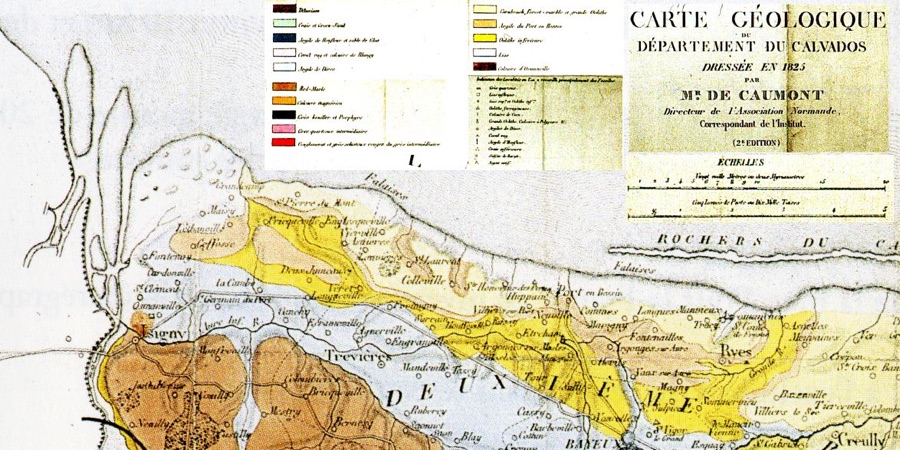
Geological map of Calvados drawn up by de Caumont in 1825, preserved in the Geology and soils file. This 19th century map illustrates much older terrain. The shore before the village
Before the houses and place names came the Bessin’s limestone plateau, its layers of marl, cliffs and the valley linking the village to the sea. The documents collected by Yves Cordelle explore this terrain through maps, geological cross-sections and coastal observations. They help explain the location of farms, springs and the former harbour. The proposed accounts of how the coast formed remain interpretations; they do not establish when Vierville was founded.
-
Bathonian and Quaternary; map of 1825 Geology and soils of Vierville
Limestone, marl, silt and ancient maps explain the formation of the territory.
-
Geological times; observations of the 19th-21st centuries Geological history of the shore
An illustrated essay on cliffs, pebbles, peats and beach transformations.
-
Various dates; landslide reported in 1984 Relief and cliffs of Vierville: descriptions and old maps
The relief explains the passages to the sea; the risk maps are old documents.
-
Various dates; 2001 nappe rise The waters of Vierville: geography and planning archives
Watersheds, watersheds and wetlands complete the reading of the landscape.
-
Bathonian and Quaternary; map of 1825
-
1158–14th century
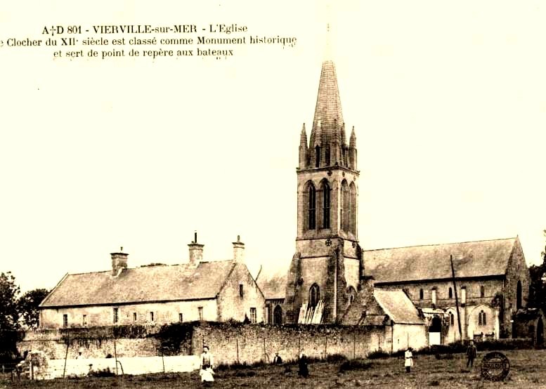
Saint-André church before the war: postcard kept in the church folder. The date of shooting is not specified in the caption. The name, the parish and the earliest lords
The archive notes record Wiarevilla in 1158 and Viarvilla in 1264. They connect the name with the personal name Wivar and a word meaning an estate. This etymology alone does not identify a founder. Saint-André’s Church and its patronage rights offer firmer evidence for the medieval village: the church dossier transcribes a donation of 1165 and dates the earliest construction to the twelfth century, with most of the building belonging to the fourteenth. The château’s history follows the local ruling families and their connections with the Bessin.
-
1158 and 1264; synthesis covering several centuries An introduction to Vierville’s history
A starting point for the village’s origins, its changes over time and the archive collections.
-
12th–16th centuries; donation of 1165 The church of Saint-André de Vierville
Architecture, patronage, transcribed documents and successive rearrangements of the church.
-
1165–15th century, then genealogies until contemporary times Families and the detailed history of the Château de Vierville
A long investigation into the families, possessions and transmissions of the estate.
-
Antiquity–20th century — ancient synthesis Administrative history of Vierville
Norman jurisdictions and maritime organization: a context to be read with a critical hindsight.
-
1158 and 1264; synthesis covering several centuries
-
16th–18th centuries
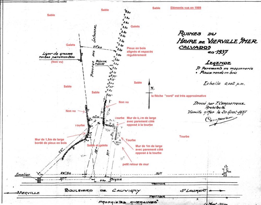
Remains of the haver: survey of Campserveux dated August 20, 1937, with observations added in red. The board bears "elements seen in 1989"; the text of the file evokes 1988. Estates and a small harbour on the Channel
Vierville’s history can also be traced through its scattered estates: Vaumicel, L’Ormel, Crespigny, Saint-Sever and Vacqueville. The entries bring together descriptions of buildings, genealogies, references to deeds and photographs. On the shore, a harbour is documented in texts of 1599 and 1604. Jean Petite’s map of 1675 already identifies it as a former port. Surveys of the remains and maritime charts offer further avenues of enquiry. Suggested links with pilgrimages or much earlier origins remain hypotheses.
-
1599, 1604 and 1675; surveyed in 1937 The port of the 16th century
Texts, plans and observations distinguish the certificates of the haven from the hypotheses on its uses.
-
1550, 1590, 1675 and following centuries Old maps and maps of Vierville and Bessin
The name of the village, the havens, the fiefs and the sea banks change from one map to another.
-
1675 — date of the card The map of the Diocese of Bayeux de Jean Petite: transcription of the cartridges
The transcribed cartouches give access to the vocabulary and intentions of this map of the diocese.
-
Late 17th century; medieval remains and subsequent rearrangements The castle of Vierville
The rebuilt castle preserves the traces of a much older domain.
Other documents and albums (6)
-
16th century; Guillaume Canivet cited in 1551 The Vaumicel
Architecture of the mansion, family stories and diary of the wars of Religion.
-
16th century; porch dated 1632 The Ormel
A manor farm, its decorations and the history of the families who owned it.
-
16th century; departure to England documented in 1687 Crespigny
The mansion leads to a family history marked by Protestant exile.
-
18th century according to historical notes; old views not all dated Saint-Sever
Postcards and landscape description of the estate, including a document dated 1912.
-
16th century; sales of 1755 and 1837 Vacqueville
The record follows the domain and the transmissions of his farm from acts cited.
-
May 11, 1724; traditions of the 19th-20th century Health and care in Vierville: historical perspectives
The leper hospital, charitable foundations and rare recollections of medical care; oral traditions are identified as such.
-
1599, 1604 and 1675; surveyed in 1937
-
1791–1805
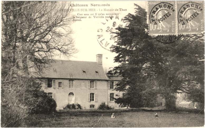
Than's mansion, park side, before its destruction in June 1944. Old postcard; date of shooting not specified. The Revolution, places of refuge and family memories
The Revolution changed institutions and left a deep mark on the village’s families. The château and Than dossiers explore these histories through individual homes. Than has a foundation stone dated 1791; a few years later, Abbé Edgeworth found refuge there. The account of his escape in 1796 compares testimonies that do not all agree on his place of embarkation. The recollections of the Countess of Hautefeuille and the autobiography of Abbé Le Paulmier offer two personal perspectives on this period rather than a complete history of the commune.
-
1791 and 1796; domain documented since the 17th century Than's mansion
The file distinguishes Than's mansion from the neighboring castle and restores its transmissions.
-
1796; departure from the coast on August 20 according to the stories cited Escape of Abbé Edgeworth, 1796
An investigation that confronts memories, traditions and archives on refuge and escape.
-
1653–20th century; religious acts from 1795 to 1804 The parish priests and the parish of Vierville
The succession of parish priests and the records shed light on the ruptures of the Revolution.
-
1792–1805; installation in Vierville in February 1805 Abbé Le Paulmier
The personal account of a priest's exile, then his return and appointment to Vierville.
Other documents and albums (1)
-
1792–1802 for childhood in Vierville; life: 1786–1861 The Countess of Hautefeuille and the castle of Vierville: biographical notice
Notes and literary excerpts put the memory of the castle back in a writer's life.
-
1791 and 1796; domain documented since the 17th century
-
1823–c. 1882
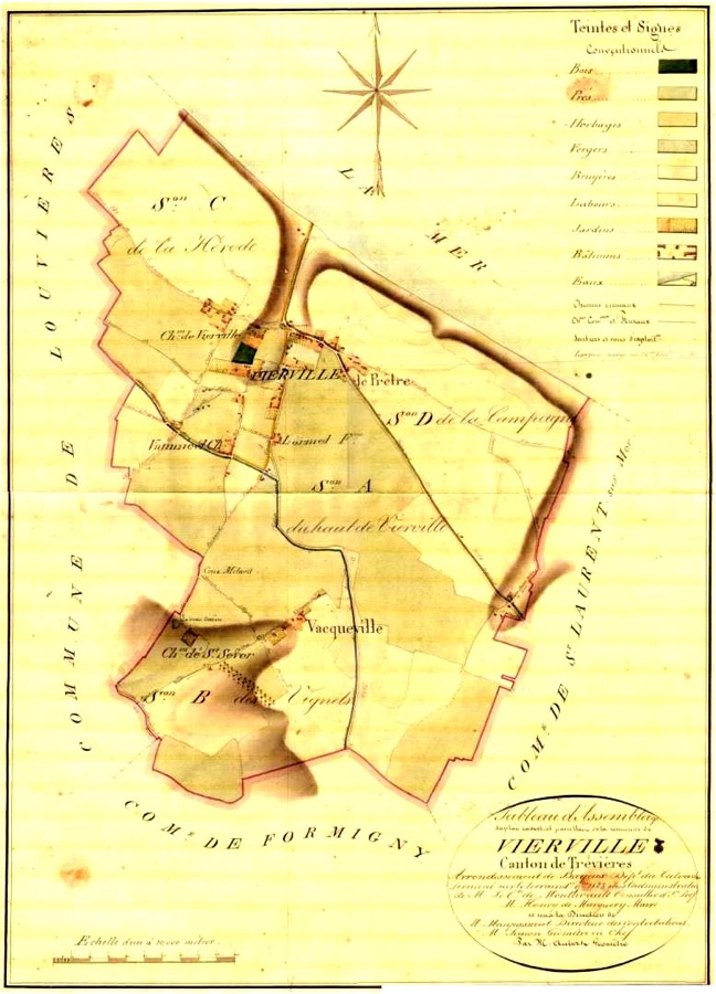
Assembly plan of the cadastre of 1823: the four sections of the municipality, before the transformations of the waterfront. Surveying the land and rediscovering the rural village
The first cadastral survey, completed in 1823, provides a detailed record of plots, paths and buildings. The division of common land in 1846 helps explain the later development of the seafront. Plans of 1844 and 1876, views of the château, farm histories, wells and population records connect the maps with the lives of local people. The documents do not always give the same dates: this guide follows the cadastral dossier for chronology and presents later recollections as testimony.
-
1823, 1844 and 1876; sketch from 1945–1946 Old cadastres of Vierville and evolution of the waterfront
General plans and details follow the plots of the village, the hamlets and the beach.
-
Around 1836 — date given by the file The Countess of Hautefeuille: excerpt from "Castles and thatched houses"
An excerpt from the Countess of Hautefeuille on large fortunes and their expenses.
-
Around 1882 — approximate dating Topographical plan of Château de Vierville and the route down to the sea
A detailed plan, accompanied by the archive’s cautions about its errors and inaccuracies.
-
19th century–2011; sometimes approximate dates and figures The population of Vierville: censuses and old developments
Demographic evolution and old comments; the alleged strong old populations are not established.
Other documents and albums (3)
-
19th-20th centuries; documents extended until the 2000s Agriculture, fishing and rural life in Vierville
A history of agricultural practices and complementary activities, illustrated with family memories.
-
Before the public distribution of 1958; precisely undated works The covered wells of Vierville
Photographs and notes on the wells of houses, farms and hamlets.
-
4 October 1995 — date of the letter Michel Hardelay: letter on the old port, the cliffs and the history of Vierville
Michel Hardelay's testimony on the port, land and sources; several hypotheses differ from other files.
-
1823, 1844 and 1876; sketch from 1945–1946
-
c. 1860–1939
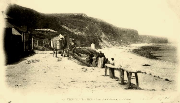
The terrace of the first Casino, by the water. Old postcard kept in the establishment's file; precise date not indicated. Villas, hotels and the little railway
Sea bathing gradually transformed a farming village. The first villas appeared towards the end of the Second Empire; Boulevard de Cauvigny and the steam tramway brought new connections around 1900. Postcards, advertisements and a 1932 brochure evoke the hotels, bathing huts and summer visits. Alongside them, the archives preserve memories of the school, shops, forge and farm work. The notes also place the official addition of “sur-Mer” to the commune’s name in this period, on 1 August 1913.
-
Around 1860–1939; guides from 1895 and 1932 Tourism in Vierville before 1939
Villas, hotels, trams and tourist documents tell the story of the transformation of the coastline.
-
End of the 19th century–after 1944 History of tourism in Vierville
Family resort, heritage and memory of the Landing intersect in this transversal file.
-
1716; tram from 1900 to 1928; coaches then The little train and the transport of Vierville: documents and photographs
Schedules, maps and photographs follow the connections of the village with the Bessin.
-
1846; road to 1900; dikes of 1936 and around 1950 The boulevard of Cauvigny: history and images of the waterfront
From the sharing of the cliffs to the villas, then to the protections and reconstruction of the seafront.
Other documents and albums (13)
-
Around 1900, 1925, 1944 and 1955 L'hôtel du Casino: postcards and history of the establishment
Postcards and advertisements explain the movements and reconstructions of the Casino.
-
August 19, 1926 "Vive Vierville": song by Simone Pourchez
The printed memory of an artistic evening, with the words of Simone Pourchez.
-
Around 1900–1950s; 1932 advertising Le Gallois establishments: bazaar, cabins and beach brasserie
Bazaar, cabins, café and brewery, before and after the destruction of the war.
-
End of the 19th century; old views not all dated The Hôtel des Touristes, now La Pie qui Tette: images and documents
Cadastres and postcards follow the crossroads building and its transformations.
-
Construction probably around 1910; 1932 advertising The Hôtel de la Plage, now Hotel de la Place: images and documents
An investigation by plans and images on this disappeared establishment.
-
1932 — date of publication Presentation of the 1932 tourist brochure
Origin and destination of the small booklet printed in Trévières for tourists.
-
1932 — date of the brochure Vierville and Saint-Laurent: tourist description and local life
A period text on mansions, the village and the beach, to be read as an advertising source.
-
Before 1944; photograph spotted from February 15, 1944 Shops, businesses and artisans
The notes identify trades, shops and inhabitants from images and memories.
-
1938; March 1937 invoice Auguste Blin, forge of Vierville: photographs of the forge
Photographs taken before the forge's disappearance show the work of the bringer.
-
1932 — date of the text; postcards not dated precisely The fish merchant and her dog hitch
A street vending practice told by the brochure and postcards.
-
1939 and June 1953 Traditional distilling: documents on making calvados
Equipment, photographs and explanations of cider distilling in the village.
-
1694–1988; 1855 and 1860 projects The school of Vierville: buildings, teachers and souvenirs
From parish foundations to public school classes, until its closure in June 1988.
-
August 1, 1913 — decree cited in the notes The addition of "sur-Mer" to the municipal name
The historical file indicates the date of adoption of the name Vierville-sur-Mer.
-
Around 1860–1939; guides from 1895 and 1932
-
1939–June 1944
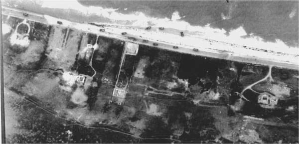
The seafront on June 6, 1944 around 11 a.m., at high tide, according to the legend of the file The Landing in Vierville. War in the life of the village
Letters from a Parisian woman who had taken refuge in Vierville offer a glimpse of mobilisation, the arrival of evacuated children and daily concerns in 1939–1940. The Resistance dossier recalls, among others, Désiré Lemière and Robert Boulard. An illustrated account of 6 June 1944 locates the fighting on the beach and in the village; other pages focus on the château, Than and L’Ormel. Aerial photographs help relate the accounts to the places themselves. The Omaha–Vierville website provides a more detailed history of the D-Day landings.
-
September 1939–1940 — dated letters Letters from a refugee in Vierville to her son in South America
A family correspondence describes the village and the concerns of the beginning of the war.
-
January 1943–June 6, 1944 The Resistance in Vierville: notes and documents
Notes and documents on the Alliance network and the arrests of May 1944.
-
June 6–7, 1944; artificial port in June 1944 The Landing in Vierville: illustrated story of June 6, 1944
An illustrated story to situate the assault, the capture of the village and the beginnings of the port.
-
1939–1947; many shots from 1943–1944 Vierville during the war and at the Liberation: aerial photographs
The photographic campaigns give a reading of the defenses, the destruction and the landscape.
Other documents and albums (4)
-
June 1940–1945 The castle of Vierville under the Occupation and during the fighting
Requisitions, military presence, bombing and damage at the level of the domain.
-
June 7, 1944 — story and testimonies The wood fights of the castle of Vierville: a story of June 7, 1944
A local episode in the path separating the castle from Than's mansion.
-
September 1943–1945 Than during the war
Requisition, German developments and consequences of the fighting at the mansion of Than.
-
June 6–7, 1944 L'Ormel in 1944
Stories and aerial views follow the soldiers and the buildings of the Ormel.
-
September 1939–1940 — dated letters
-
1944–c. 1960
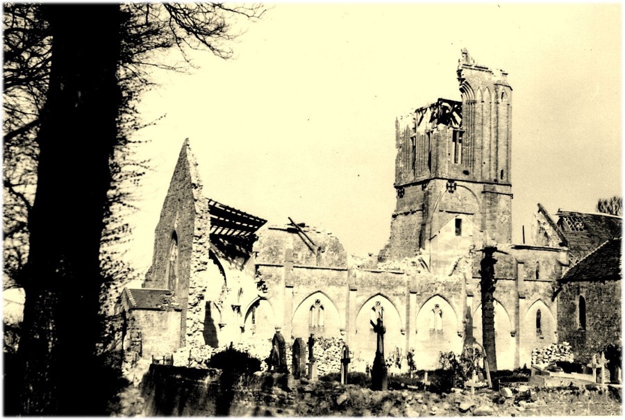
The church of Saint-André in 1945, according to the legend preserved in the file on public buildings. Living among the ruins, then rebuilding
The end of the fighting did not immediately restore normal life. Homes and public buildings lay destroyed, roads were damaged, fields remained mined and wrecks obstructed the shore. The reconstruction dossier follows the years of temporary premises, war-damage claims and building work. Demining in 1946–1947 and wreck salvage in 1949–1955 form two parts of this story. For seafront homes, individual collections compare plans, pre-war views and photographs of the ruins with the gradual rebuilding of the 1950s.
-
1943–around 1959–1960 War destruction and reconstruction
A working file distinguishes the causes of the destruction and the stages of reconstruction.
-
6–7 June 1944–late 1950s The public buildings of Vierville: destruction and reconstruction
Bombing, temporary premises and reconstruction of municipal facilities.
-
1944–post-war period; dates vary according to the house Houses of the village and hamlets: destruction and reconstruction
Damage and reconstruction of houses and interior domains.
-
1939–after 1944 The Vierville waterfront before and after the war destruction
A general entry to compare the pre-war coastline and the destruction.
Other documents and albums (10)
-
Before 1944–after the war; plans for 1946 Rues de la Mer et de la Percée: destruction and reconstruction
Houses, owners and damage are spotted in the descent to the beach.
-
1943–post-war period; background of the 1946 plan Boulevard de Cauvigny, west sector: destruction and reconstruction
From the National Guard monument to Mont-Olive, the first destructions precede the Landing.
-
1939–after 1944 Boulevard de Cauvigny, center-west sector: destruction and reconstruction
Maps, photographs and notices of the villas between Mont-Olive and Villa Hardelay.
-
1944–post-war; sketch around 1945–1946 Boulevard de Cauvigny, central-east sector: destruction and reconstruction
The villas between Clairefontaine and Les Hortensias through war damage.
-
1944–post-war; sketch around 1945–1946 Boulevard de Cauvigny, east sector: destruction and reconstruction
Ruins and reconstructions up to the limit of St. Lawrence.
-
1949–1955; state of the shore in 1945 Post-war wreck salvage off Vierville
Photographs and notes on remains of the artificial harbour and salvage work.
-
After 1944; Bedford Avenue in service in 1956 Roads, networks and agricultural land: the reconstruction of Vierville
Restore traffic and restore land after the departure of the armies.
-
1946–early 1947 The demining of Vierville after the war
Land remained mined and civil demining operations.
-
June 6, 1944–1950s; bell tower rebuilt in 1953 The destruction of 1944
Story of the shots, views of the ruins and reconstruction of the bell tower.
-
1944 for destruction; previous views not all dated The Islands
Postcards and photographs keep track of the castle and farms in the neighborhood.
-
1943–around 1959–1960
-
1947–2014
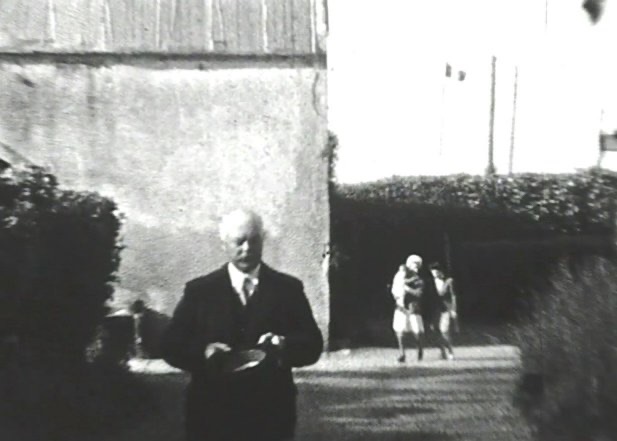
Arrival of Mayor Fernand Leterrier at the castle, October 1947. Family photograph; the exact purpose of the ceremony is not specified. Remembering and passing on the story
Ceremonies, monuments and meetings with veterans gradually became part of village life. Family photographs record a ceremony at the château in October 1947; the monuments dossier then traces the creation of places of remembrance. Reports on the anniversaries held between 1994 and 2014 show how remembrance has been shared with younger generations. Associations, the twinning with Bedford and local museums add to this history. These are dated records of past events, rather than a programme of present-day ceremonies.
-
October 1947 — object of the ceremony not specified A ceremony at the Château de Vierville: family photographs
Some family photographs show the mayor, officials and participants in the castle.
-
After 1944; National Guard memorial inaugurated on June 5, 1969 The memorials of Vierville: images and history
Plans and photographs document the construction and evolution of places of memory.
-
June 6, 1994 The 50th anniversary of the Landing in Vierville
Preparations, ceremonies and many documents on the fiftieth anniversary.
-
June 6, 1999; visit of young Americans in July 1999 The 55th anniversary of the Landing in Vierville
The images of this year of commemoration and exchanges.
Other documents and albums (9)
-
June 6, 2004 The 60th anniversary of the landing in Vierville
Ceremonies, music and gatherings for the sixtieth anniversary.
-
June 2007; concert on June 8 Commemorations of the Landing in Vierville — June 2007
Meetings with students and Peace in the church concert.
-
June 6, 2010 Ceremonies and tributes to the Resistance in Vierville — June 6, 2010
Street openings and tribute to Désiré Lemière, Robert Boulard and Jean Roger.
-
June 6, 2011 Commemorations of the Landing in Vierville — June 6, 2011
A series of photographs of the annual ceremony.
-
May 8, 2012 May 8 ceremonies in Vierville and Trévières
Ceremonies in Vierville and Trévières in the presence of a Bundeswehr delegation.
-
June 2012 June ceremonies: Norman White and Deep Respect
Images of the tributes to Norman White and Deep Respect.
-
June 6, 2014; 2014 additional documents The 70th anniversary of the landing in Vierville
Reports, veterans, vehicles and music around the seventieth anniversary.
-
1976–2014 in documents; twinning charter in October 1997 Memory associations — history and documents
Articles and photographs on veterans and exchanges between residents.
-
1980–2013; first museum from 1985 to 1993 The museums of the Landing in Vierville: history and collections
From the first exhibitions to the two successive museums, a local history of the collections.
-
October 1947 — object of the ceremony not specified
-
1958–2016
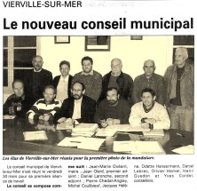
The new municipal council on March 30, 2001, according to the file Mayors and municipal councils. Press clip kept in the fund. Changing the village and preserving its records
After reconstruction, utilities and public facilities changed everyday life. The public-services dossier dates the introduction of mains drinking water to 1958. Other pages follow the village hall, school, post office, shops and former Trévières intercommunal authority, established around 1999–2000. Two separately organised collections place decisions and debates in context: municipal newsletters from 2002 to 2016 and council meeting records from 2005 to 2012. Earlier land-use and local planning documents extend this history in Maps and landscapes.
-
1958 for drinking water; technical records of the 2000s History of intercommunal networks and services
Water, sanitation and other services are described in their historical state.
-
Since 1945; party hall around 1960 and renovation in 1994 Municipal events after 1945
Press clips and photographs on the facilities, shops and events of the village.
-
Since the Revolution; incomplete list before 1842 Mayors and municipal councils of Vierville
A history of elected officials accompanied by photographs and landmarks on old sessions.
-
December 29, 1999–1 January 2000; archives of the following years The former intercommunality of Trévières
Its creation and some common activities, including the leisure center.
Other documents and albums (5)
-
Undated document — former territorial organization Municipalities of the former intercommunality and parish boundaries
A plan and a list from the old file; they do not describe the current organization.
-
1986–2009 for successive organizations Initiative unions and tourist offices: a local history
Initiative syndicate and tourist offices through their articles, guides and old programs.
-
Various dates; bulletins from 2002 to 2016 Archives of communal life
The gateway to bulletins, minutes, elected officials and village services.
-
November 2002–June 2016 — 28 issues Municipal bulletins — archives from 2002 to 2016
Read the issues retained as sources of local life on their date of publication.
-
2005–2012; an undated document City Council — archived minutes and deliberations
Find the 47 entries, with date differences and incomplete documents reported.
-
1958 for drinking water; technical records of the 2000s


