
The reconstruction of Vierville
5 - Roads, public networks and agricultural land
1 - After the war, the existing public roads were often widened but in very poor condition and worn out until the destruction of the roadway.
In addition, new roads, more or less well stoned, had been created through private properties, to ensure new links, and sometimes doubling existing roads that were too narrow.
After the departure of the Americans, these roads were quickly returned to their previous uses by the residents who put in place the fences and barriers they urgently needed to fence the grass. Their animals were sometimes landless for several months and had to be slaughtered.

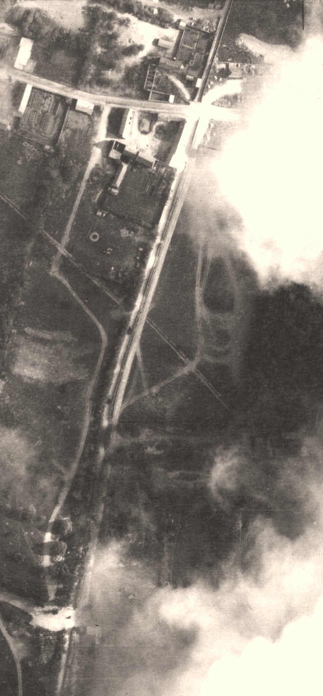
For example, a road had been created through the Briscsart field to directly connect the descent to the sea and the path of the Ash Hunt in front of the mansion of Than. For its part, the main crossroads had been considerably enlarged (photo August 10, 44)

The East perimeter wall and the road traced by the US Engineer in the Bricsart field in winter 1945.

The road built to directly connect the Hamel road to the Priest and the St. Lawrence road
(Photo August 10, 1944)
Another example: the chemin de la Chasse au Prix had been split by a path created in the nearby field of the Fossé-Gras
(Photo August 10, 1944)

New roads framed this field bordered on the cliff by 2 large hedges of black pines
(Photo August 10, 1944)
Below, a track created by the Americans, which foreshadows the future rue des Ecoles. This path served in particular American dam balloons that can be seen on the right in the photo
Two steep temporary roads had been created by the Engineers to descend from the cliff, they were used for the empty return of "ducks" and trucks.
A first road had been built at the site of the villa Roger (Sainteny), today villa Philippe Marchal). She connected the plateau (where the 2 black pine hedges are located) to the beach, taking advantage of a favorable terrain movement. (photo August 10, 1944)

A second downhill road had been built at Mount Olive, above the Petel villa (Villa Curto today) (photo August 10, 1944)
Below, around 1950, the same road was disused. The municipality had considered at the time to create a pedestrian path on this route

A huge embankment had been created in the valley of Vierville to serve the Mulberry port and for the transfer station between "ducks" and trucks. This land was used to create the Avenue de Bedford, which improved the descent into the sea. Before the war, this was done by the narrow Rue de la Mer, now a local service.
On the view below on the left, from the summer of 1947, the large embankment remained uncultivated in the Vierville valley and traffic was still on the rue de la mer


Winter 1945, the big land full shortly after the departure of the Americans

The great full land, where there was a pond surrounded by walls

In the bottom of the land we could see the remains of the villa Rinascente and the annex of the villa Cusinberche

In 1956, Bedford Avenue (it will bear this name later) was in service.
Its final shape can be seen in the 1965 aerial photo, below
Another important detour was created a few years after the war: the Formigny road, which originally bypassed the cemetery and the church passing along the property of the Manoir de Than, was moved to pass east of the church, thus avoiding the 2 right-angled turns around the cemetery.
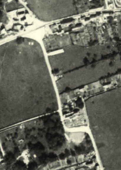
In 1947, the road still passed around the cemetery, the church and the bell tower were still in ruins, the temporary chapel was visible in the photo, not far from the crossroads.

In 1955, the new road left the church and cemetery to the west. The bell tower was rebuilt, but the church was still without a roof. The cemetery was not yet fenced on the Than mansion side.

In 1958, the church was completed reconstruction, the cemetery had its new fence wall. The temporary chapel was still in place (we see it behind the bell tower).
At the bottom we see the brand new Bedford Avenue which was perhaps still unfinished.
2 - Public networks various
- The electrical distribution was out of order, it dated from 1930. In particular, the castle was connected at this time.
It seems that the distribution was put back into service in 1945, at least partially.
- The public lighting had disappeared,
This lighting was apparently limited to a street lamp suspended at the corner of the school housing building, visible on the postcard below.
See the lantern on the enlargement on the right
This lighting was equipped with a timer, also demolished in 1944.
.
The building, damaged during the June 7 bombing, was quickly rased to allow the enlargement of the crossroads. This main outlet for the D1 beach outing was indeed essential for Americans.

The public lighting lantern before the war. It was placed at the central crossroads of Vierville. Question to the elders of Vierville, who is the person walking in front of the building??
- The small telephone network had disappeared. It consisted of a limited number of non-automatic stations, a network installed shortly before the war.
Few people were connected, they had to call a telephone operator installed at the Trévières Post Office, who connected the requested correspondent.
For example, the connection of Mrs. Hausermann (to the Château de Vierville) was made for the first time in early January 1940. Here is what she wrote on 9 January 40 excerpts:
"....... My phone is being installed right now, portable device in my small living room, double ringing (one in the kitchen) this will be practical, although since the war, it is forbidden to call from dept. to dept. I hope to be able to call your sisters for health reasons (at the time we always went through an operator in our countryside; the machine existed in Paris and in big cities, and of course not for inter-urban). The English who are masters of the department are fierce about this, in any case it will make it easier for races in Trévières, Bayeux, etc; because once the sisters are gone I am absolutely on foot. "
This network seems to have been put back into service in a limited way as early as 1945?
- For the record, there was a complete absence of drinking water distribution and sanitation.
A public washhouse was located in the center of the village. The basin still exists in the Fontaines district, but it is now dry. Nearby was a small pond called the pond or the drinker, dry today and not maintained. (See page 6531 photos of this pool)
Each house had its well(s) for domestic needs. The water table was very close, usually 2 or 3 meters deep. See page 649, the old covered wells of Vierville
Water was drained in lost wells, including for toilets, generally placed at the end of the garden, as far as possible from the wells used for domestic needs. Only a few houses had summary septic tanks, without treatment of effluents that were sent to pits dug under the toilets.
The largest houses had an indoor distribution under pressure and had the water quality checked annually by the pharmacist of Trévières.
Most grasses and farms had a mare for cattle or ducks. These ponds were abandoned and blocked in the post-war years (for example the Bricsart pond). The large pond located in the grasslage opposite the castle had been filled by the Americans for their circulation needs.
See page 46 the presentation of a teacher - secondary resident - on the batracians of Bessin and his desire to see ponds put back in place in Vierville. This would make it possible to find some of the diversity of wild species.
The public drinking water distribution was installed in the 1950s.
As for the'collective sanitation, it was carried out in 2004-2005 for the largest part of the agglomeration population. More dispersed habitats are now bound by individual sanitation in accordance with strict standards.

The inauguration of the Vierville treatment plantRead the rewritten text
This reading version has been rewritten from the newspaper clipping. Connecting phrases and any reconstructed words are not a verbatim quotation.
One Friday afternoon, the Vierville-sur-Mer treatment plant, Grandcamp road, was inaugurated in the presence of Roger Jouet, Vice-President of the General Council. After cutting the ribbon, he invited the personalities to visit the facilities.
Mayor Jean-Marie Oxéant explained the wastewater circuit: they descended by gravity towards the beach, then pumps sent them back to the lagoon. The treatment was based on their slow passage from one basin to another until the fourth, with a reduction in discharges by evaporation and by the action of the wind. The mayor highlighted the simplicity of this system and its ability to absorb significant population variations in the four municipalities, from Sainte-Honorine-des-Pertes to Vierville.
However, the project manager announced the cancellation of a spreading demonstration: the fourth basin contained too little water. The lagoon had just been put into service, all the inhabitants were not yet connected and the strong heat of the previous weeks favored evaporation.
Jean-Marie Oxéant recalled the entry into the active phase of the union in January 1999. The objectives were to improve bathing waters, to bring comfort to residents, to better manage the urban planning of the four municipalities and to promote tourism as an economic engine of the canton of Trévières. The operation was to be provided by the SOAF.
During the wine of honor in the communal hall, he thanked his three vice-presidents, Raymond Birabent for Sainte-Honorine-des-Pertes, Patrick Thomas for Colleville-sur-Mer and Raymond Mouquet for Saint-Laurent-sur-Mer, as well as all the delegates. He stressed that real collective work had made it possible to overcome the obstacles.
Roger Jouet presented the inauguration as the culmination of a long file and a dream sometimes considered unrealizable. He recalled that the absence of all-in-the-sewer in Omaha had long slowed down equipment and investments. The local will and the cohesion of the elected officials within the union had finally allowed the realization of the sanitation network.
View the archive imageDownload the rewritten text
Original OCR text
The original OCR text is kept for comparison with the image. Its reading order and some words may be incorrect.
Inauguration of the treatment plant, 2005

On this approximate plan of 1882, we see the 2 ponds that have disappeared since the war and the lavoir of Vierville. The latter was rather in the form of the plan below

Plan of 1872

The arm pump next to the church, it still works, a memory of the not so distant time when public water distribution did not exist (before 1955)
3 - Grasslands, woods and plows have been occupied for many years, sometimes arranged by the Germans with constructions of concrete or non-concrete shelters, underground. For example, the wood of Than's mansion was full of a dozen buried shelters.
The American occupation was much more intense but lasted only 6 months.
Below and opposite, examples of occupations of agricultural spaces in Vierville during the summer of 1944: alignments of tents, vehicles, food depots, equipment, ammunition, DCA batteries (40mm Bofors cannons or quadruple heavy machine guns), dam balloons, etc...

Example of American camps on the St. Lawrence road

In this photo of summer 44, we see at the bottom left, the hernage of the Fossé Gras, next to the castle wood, occupied by many vehicles and tents

The plan of the many shelters built by the Germans in the park of the mansion of Than.

American camps on the Formigny road

US Camps in Fosses Taillis
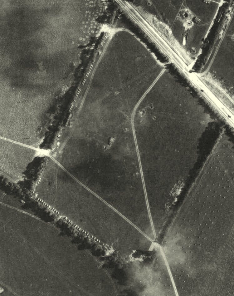
Example of a grass where the hedges are lined with individual tent alignments (Saint-Laurent road)