
This inventory of wood and hedges comes from the urban planning documents gathered in the fund. He keeps a dated description of the landscapes of Vierville and the protection proposals then studied.
The remarkable wooded areas of Vierville
(extracts from PLU investigation files and wooded areas, these documents are provisional, they will be modified when the Local Urban Planning Plan is adopted)
In accordance with the Urban Planning Code, the most significant wooded areas in the municipality of Vierville sur Mer must be registered in wooded areas classified (E.B.C.) in the Local Urban Planning Plan.
In addition to the classified wooded areas, the spaces deemed interesting by the community may also be classified to protect and preserve, even if the vegetation that is located there does not represent major interest for forestry. This classification may also concern isolated trees, hedges or alignment plantations, or any linear aforest. In this case it is the
Article L123-1-5 7° of the Urban Planning Code which will apply.
As such, the regulation can "Identify and locate landscape elements and delimit neighborhoods, blocks, buildings, public spaces, monuments, sites and sectors to be protected, enhanced or requalified for cultural, historical or ecological reasons and define, if necessary, the requirements likely to ensure their protection"
A study of these spaces was undertaken as part of the Local Urban Planning Plan
The following criteria have been retained for this
- The situation of the wood (urban spaces, natural spaces, valleys, seaside, etc.);
- The size and general condition of the wood;
- The variety of species and vegetation strata;
- The perception of wood in its environment (landscape role);
- The role in water protection;
- The ecological role (notion of "biological corridor" with other plant formations).
The work consisted of the examination of aerial photographs, completed by field work (a survey of the species and appearance of the aboisement) and a photographic report on each site, to judge the character of the afforesting, their landscape impact, and their ecological value.
When it was drawn up to its Land Use Plan, the municipality of Vierville had already registered its classified wooded areas in 1995, which were then divided into 12 wooded complexes (8.49 ha) and 15 sets of hedges (7305 linear meters) (see figure No. 1).
The observation of the IGN map (Figure No. 2) and the aerial photography (Figure No. 3) made it possible to identify other areas to be checked in the field.
Thus, 33 wooded sets (14 woods and 19 hedges) were the subject of a field visit (numbered in Figure No. 3).
Each wooded set is presented. An analysis of each site makes it possible to judge its "significant" character at the municipal level and leads to a "prosition" of classification or non-ranking.
Following the investigations, these proposals will be judged and will be used for the classification that will finally be adopted for the PLU and which we therefore do not yet know.


List of wooded areas studied, with proposal for classification or non-classification, downgrading or maintenance of classification:
(The No. of the space studied begins with a B for aforing and an H for hedges
The location indicates the cadastral number and the area in ha for woods and the linear in m for hedges)
14 WOOD studied
Bois B1 - Southeast of Saint-Sever, at the end of the CR30 called de la Fosse - OB117, 120, 121, 122, 125 and 126 - 2.69 ha
Wooded Set n°B1 (classified in POS 1995):
Location: At the end of the rural road n°30 called de la Fosse, in agricultural space; after verification on aerial photo and on the land, the plots indicated in the table on page 2 (parcels classified in the POS of 1995) do not correspond to the land: the really wooded plots are the plots OB117, 122, 123 and 126
Size and general condition: 3 parallel woods of 1.98 ha in good condition
Variety of species and vegetation strata: wooded stratum: sycomore maple, cherry, ash; shrub layer: hawthorn, hazelnut, elm, salerberry
Perception of the wood in its environment: not very visible aforement, but contributes to the density of the grove
Role in water protection: none
Ecological role: Ecological interest to preserve because the aforest serves as a shelter and can be used for bird nesting. Ecological corridor with other wooded areas nearby.
This large wooded area deserves a classification because of its role in protecting the water resource and its ecological interest.
Proposal to maintain the ranking with modification of limits
Wood 1 - Maintenance of classification with modification of limits -OB117, 120, 121, 122, 125 and 126 - 1.98 ha

Ranking of 1995

Situation of really wooded parcels in 2010


Bois B2 - Along the Fumichon stream OB147 borders OB161 and 146 - 0.91 ha
Wooded Set No. B2, classified in POS 1995:
Location: Close to the castle of Saint-Sever, on the edge of the Fumichon stream, in agricultural area; plot OB147 and borders OB161 and 146
Size and general condition: 0.91 ha of aforestation in very good condition, with very varied species; attention to the proximity of Renouée du Japon (plant devoid of local predators and competitors, it has proven to be very invasive and therefore unfavorable to biodiversity)
Variety of species and vegetation strata: the species present are at different stages of strata. It was observed: sycomore maple, chestnut tree, ash, linden, elm, field maple, hawthorn, cornwel, elderberry, clematis, holly, laurel, iy, hazelnut, gooseberry
Perception of wood in its environment: little landscape interest because it is not very visible, but participates in the bocagère density.
Role in water protection: borders the Fumichon
Ecological role: Ecological interest to preserve because aforest serves as a shelter for wildlife and can be used for bird nesting. Ecological corridor with other wooded areas nearby.
This wooded area deserves a classification because of its role in protecting the water resource and its ecological interest.
Proposal to maintain the ranking
B2 - Maintenance of the ranking - OB 147, borders OB161 and 146 - 0.91 ha


Bois B3 - On the edge of the Fumichon stream, near the castle of Saint-Sever OB140 - 0.27 ha
Wooded Set No. B3 (classified in POS 1995):
Location: Close to Château Saint-Sever, on the edge of the Fumichon stream, in a semi-agricultural area; plot OB140
Size and general condition: 0.27 ha of forest which is part of the private park of Château St Sever. It has few varieties of trees but these are generally large. The aforestation is walled on one side.
Variety of species and vegetation strata: Afforestation is essentially represented by the wooded stratum (ash or sycomore maple) and some shrubs (hawthorn, hazelnut?);
Perception of wood in its environment: This aforesting participates in the green setting of the castle
Role in water protection: borders the Fumichon
Ecological role: Ecological interest to preserve because aforest serves as a shelter for wildlife and can be used for bird nesting. Ecological corridor with other wooded areas nearby.
This wooded area deserves a classification because of its role in protecting the water resource and its ecological interest.
Proposal to maintain the ranking
B3 - Ranking maintenance - OB140 - 0.27 ha


Bois B4 - On the edge of the Fumichon stream - OB139 - 0.10 ha
Wooded Set n°B4 (classified in POS 1995)
Location: on the edge of the Fumichon stream, in an agricultural area; plot OB139
Size and general condition: woodland of 0.10 ha in good condition, quite humid because of the passage of the Fumichon
Variety of species and vegetation strata: ash, plum tree, willow, hazelnut, holly, raise
Perception of wood in its environment: On the one hand, this aforesting participates in the framework
Green of the castle, on the other hand with the bocagère density
Role in water protection: bordering the Fumichon, wetland
Ecological role: Ecological interest to preserve because afforest serves as a shelter for wildlife and can be used for bird nesting. Ecological corridor with other wooded areas nearby.
This wooded area deserves a classification because of its role in protecting the water resource and its ecological interest.
Proposal to maintain the ranking
B4 - Ranking maintenance - OB139 - 0.10 ha


Bois B5 - On the edge of the Fumichon stream - OB136 - 0.52 ha
Wooded set n°B5 classified in POS 1995:
Location: Close to Château Saint-Sever, on the edge of the Fumichon stream, in agricultural space; plot OB147 and borders OB136
Size and general condition: wooding of 0.52 ha in good condition
Variety of species and vegetation strata: The most represented stratum is the wooded stratum (without dominant species) with some shrubs: sycomore maple, fir, beech, hawthorn, holly, oak, lime, clematis, elderberry, elkworm
Perception of wood in its environment: little landscape interest because it is not very visible, but participates in the bocagère density
Role in water protection: borders the Fumichon
Ecological role: Ecological interest to preserve because aforest serves as a shelter for wildlife and can be used for bird nesting. Ecological corridor with other wooded areas nearby.
This wooded area deserves a classification because of its role in protecting the water resource and its ecological interest.
Proposal to maintain the ranking
B5 - Maintenance of the ranking - OB136 - 0.52 ha


Bois B6 - Ferme de l'Ormel North border - OA98 and 99 - 0.52 ha
Wooded Ensemble n°B6 (classified in POS 1995):
Location: Ferme de l'Ormel, northern border of plots OA 98 and 99, in a semi-agricultural area, semi-urbanized
Size and general condition: 0.52 ha of degraded aforest because part has been cut, but regeneration is possible because young plants (of sycomore maple) are visible; the small aforest has become a medium quality hedge
Variety of species and vegetation strata: The wooded stratum is the majority with many brushwoods (brames). The species represented are: oak, ash, elm, elmer, maples in young plants
Perception of wood in its environment: serves as a windbreak and landscape element on the fairly open agricultural plateau, but also as an integration of the building
Role in water protection: Presence of a pond
Ecological role: low ecological interest due to the non-continuity of the hedge with other hedges
This wooded area deserves a classification because of its landscape role.
Proposal to maintain the ranking
B6 - Ranking maintenance - North Border OA98 and 99 - 0.52 ha


Bois B7 - Than Manor Park- Part AH20 - 0.16 ha
Wooded Set n°B7 (classified in the POS 1995)
Location: in Than Park on part of plot AH 20, in semi-urbanized space
Size and general condition: it is a private park made up of different species sometimes ornamental, and with beautiful subjects. 0.16 ha are currently classified but the rest of the plot also has forests (about 0.97 ha)
Variety of species and vegetation strata The park is dominated by the wooded strata. The species present are: sycomore maple, linden, pine, holly, laurel, elberry, elberry, cherry...
Perception of wood in its environment: participates in the landscape integration of the church
Role in water protection: none
Ecological role: Ecological interest to preserve because aforesting can be used for bird nesting. Ecological corridor with other wooded areas nearby.
- This wooded area deserves a classification because of its landscape role and ecological interest.
Proposal to maintain the ranking with enlargement of the delimitation
B7 - Maintenance of the ranking with enlargement of the delimitation - Part AH20 - 1.13 ha


Bois B8 - Vierville Castle Park - AH14 - 1.33 ha
Wooded Set n°B8 (classified in POS 1995):
Location: Château de Vierville, in a semi-urbanized area, plot AH14
Size and general condition: 1.33 ha of forestage in good condition, with large subjects
Variety of species and vegetation strata: The majority stratum is wooded. The species are very varied with sometimes ornamental species. The species present are: sycomore maple, linden, cherry laurel, sauce laurel, plane tree...
Perception of wood in its environment: participates in the landscape integration of different sites (church and castle of Vierville)
Role in water protection: none
Ecological role: Ecological interest to preserve because aforest serves as a shelter for wildlife and can be used for bird nesting. Ecological corridor with other wooded areas nearby.
This wooded area deserves a classification because of its landscape role and its ecological interest.
Proposal to maintain the ranking
B8 - Maintenance of the ranking - AH14 - 1.33 ha


Bois B9 - At the entrance of the castle of Vierville - AH88 for part - 0.12 ha
Wooded Set No. B9 (classified in POS 1995)
Location: Château de Vierville, in a semi-urbanized area, plot AH88 for part
Size and general condition: 0.12 ha of afforestation in good condition, with large subjects
Variety of species and vegetation strata: The majority strata is wooded. The species represented are: chestnut tree, sycomore maple, pine, weeping ash
Perception of wood in its environment participates in the landscape integration of the Château de Vierville, especially in the crossroads going to the sea
Role in water protection: none
Ecological role: Ecological interest to preserve because aforest serves as a shelter for wildlife and can be used for bird nesting. Ecological corridor with other wooded areas nearby.
This wooded area deserves a classification for its landscape role and ecological interest.
Proposal to maintain the ranking
B9 - Ranking maintenance - AH88 pie - 0.12 ha


Bois B10 - called the "Côtis", located west of Bedford Avenue- AB165 and 124, OC91 - 1.20 ha
Wooded Set n°B10 (classified in POS 1995):
Location: Coteau located west of Bedford Avenue in semi-urbanized space (at the back of houses), parcels n°AB165 and 124, and OC91
Size and general condition: This is a place that is not very accessible because it is quite steep, which has stuck. This set consists of brushes evolving towards a shrub stratum, even wooded but stunted by the effect of the wind. This is an impenetrable space.(Before the war, a private hiking trail ran it towards the sea).
Variety of species and vegetation strata: Bushing to shrub strata are dominant: tamaris, brambles, eaderberry, clematis. Beware of the presence of Japanese Renoue (plant devoid of local predators and competitors, it proved to be very invasive and therefore unfavorable to biodiversity).
Perception of wood in its environment: Although consisting mainly of brush giving the impression of an unmaintained space, it adds to the variety of land use and avoids a certain monotony of the landscape.
Role in water protection: This set stabilizes the hillside.
Ecological role: Ecological interest to preserve because aforest serves as a shelter for wildlife and can be used for bird nesting.
This wooded area deserves a classification because of its role in soil stabilization and its ecological interest.
Proposal to maintain the ranking.
B10 - Ranking maintenance - AB165 and 124, OC91 - 1.20 ha


Bois B11 - East Coteau de la rue de la Mer- AB111, For part: AB122, 115, 117 -0.44 ha
Wooded Set n°B11:
Location: Coteau located to the east of Boulevard de Cauvigny, in semi-urbanized space (at the back of houses), parcels n°AB111 and partly of the parks they AB 115, 117 and 122
Size and general condition: This is a place that is not very accessible because it is quite steep, which has stuck. This set consists of brushwood evolving towards a shrub with wooded stratum. This is a space that is difficult to access.
Variety of species and vegetation strata: All strata are represented with a dominance of brush. The species present are: yel, brambles, tamarish, ivery, elder, ash.
Perception of wood in its environment: Although consisting mainly of brush giving the impression of an unmaintained space, it adds to the variety of land use and avoids a certain monotony of the landscape. It also helps with the integration of the building.
Role in water protection: This set stabilizes the hillside.
Ecological role: Ecological interest to preserve because aforest serves as a shelter for wildlife and can be used for bird nesting.
This wooded area deserves a classification because of its role in soil stabilization and its ecological interest.
Proposal to maintain the ranking
B11 - Ranking maintenance - AB111, For part: AB122, 115, 117 - 0.44 ha


Bois B12 - Entrance to Saint-Sever Castle - OB 156 and 157 - 0.23 ha
Wooded Set n°B12:
Location: Château de St Sever, in agricultural area, parcels OB156 and 157
Size and general condition: 0.23 ha of wooding in good condition
Variety of species and vegetation strata: The majority stratum is wooded. The very varied species are: chestnut, beech, sycomore maple, field maple, ash, hazelnut, holly, hawthorn, eelmow
Perception of wood in its environment: participates in the landscape integration of the Château de Saint-Sever
Role in water protection: borders a pond
Ecological role: Ecological interest to preserve because aforest serves as a shelter for wildlife and can be used for bird nesting. Ecological corridor with other wooded areas nearby.
This wooded area deserves a classification because of its landscape role and its ecological interest.
Proposal to maintain the ranking
B12 - Ranking maintenance - OB 156 and 157 - 0.23 ha


Bois B13 - Coteau between the urbanized coastline and the "countryside" (agricultural plateau on the edge of a cliff)-? - Wooded Set n°B13:
Location: Cliff located between the urbanized coastline of the waterfront and the agricultural plateau (section AB, part of parcels 13, 14, 15, 276, 17, 18, 19, 20, 132, 131, 22, 23, 24, 25, 26, 27, 28, 29, 30, 31, 32, 60, 34, 35, 36, 37, 255, 256, 233, 39, 40, 82, 84; section AC, whole plots: 8, 73, 74; part of the plots: 16, 19, 24, 25, 29, 30, 78, 79.80;
AD section, entire parcels: 79, 80, 11, 68; part of parcels: 1, 71, 72, 76, 5, 7, 41, 69, 56, 57, 59, 62, 68.)
Size and general condition: This is an area with steep slopes, difficult to exploit and accessible, which tends to get snarken. This space extends over a distance of about 1600 m and an average width of 40 m.
Variety of species and vegetation strata: The strata are very variable and evolutionary: there is the herbaceous stratum, the shrubby stratum with brush and the tree-lined stratum but stunted because of the wind. Some may have been planted by the owners (cypresses). The species present are: tamaris, bramble, elderberry, cypress...
Perception of wood in its environment: Although consisting mainly of brush giving the impression of an unmaintained space, it adds to the variety of land use and avoids a certain monotony of the landscape. It also helps with the integration of the building. In addition, it gives a "wild" aspect to this coastline.
Role in water protection: This set stabilizes the steep slope.
Ecological role: Ecological interest to preserve because aforest serves as a shelter for wildlife and can be used for bird nesting. It constitutes in itself an ecological corridor by its length.
This large semi-wooded area could deserve a ranking for its role in soil stabilization, landscape role and ecological interest, but given the complexity of natural environments and the proximity of housing, it is difficult to classify this space.
The municipal council has retained the non-classification as a wooded area, but only the protection under Article L123-1-5-7° "of the vegetation strip on the edge of the plateau" described as "wooded area to be protected". This area is classified N north of the plots classified U, Ua and Ub along Boulevard de Cauvigny.
Protection proposal:
B13 - Section AB, part of parcels 13, 14, 15, 276, 17, 18, 19, 20, 132, 131, 22, 23, 24, 25, 26, 27, 28, 29, 30, 31, 32, 60, 34, 35, 36, 37, 255, 256, 233, 39, 40, 82, 84; section AC, entire plots: 8, 73, 74; part of parcels: 16, 19, 24, 25, 25, 30, 78, 79, 80; section AD, whole parcels: 79, 80, 11, 68; part of parcels: 1, 71, 72, 76, 5, 7, 41, 69, 56, 57, 59, 62, 68. - 0


The map above is an approximate mapping of the vegetation strata present and shows the complexity of this space.

Above, area B13 selected for the original study.
Below, zone B13 retained for protection under Article L123-1-5-7° of the Urban Planning Code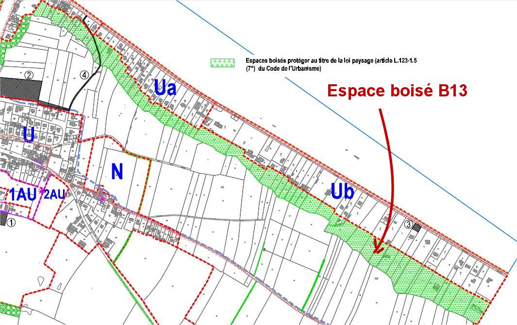


Bois B14 - In the middle of the Vignets, close to the CR called the Teurterets- OA71
Wooded Set n°B14:
Location: Close to the rural road called Teurterets, part of the plot OA71 indicated in aforesting on the IGN map
Size and general condition: After field verification, the plot is not wooded
Variety of species and vegetation strata: none
Perception of wood in its environment: nothing
Role in water protection: nothing
Ecological role: none
Proposal of non-classification
B14 - No ranking OA71 0


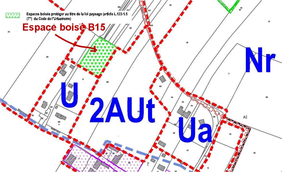
Bois B15 - Small orchard, close to the Grandcamp road,
Proposal adopted by the municipal council on 1/9/2011, for the PLU:
Classification of the orchard of the plot "I- 2" in wooded area to be protected with transfer to NR zone
TOTAL OF THE WOODS studied 8.49ha / proposed in the ranking about 9 ha
_______________________________________________________________________________________
16 HEDGES studied
Haie H1 - Along the CR des Fosses Taillis - Border OA 67, 66, 65, 64, 63, 61, 41, 42, 43, 38, 11, 12 and OA 37, 36, 44, 45, 47, 60, 59 - 1865 m
Wooded Set No. H1 (classified in POS 1995):
- Location: along the rural path called Fosses Taillis, in an agricultural area;
On the edge of plots OA 67, 66, 65, 64, 63, 61, 41, 42, 43, 38, 11, 12 and OA 37, 36, 44, 45, 47, 60, 59
- Size and general condition: about 1865 ml of hedges in good condition, with all strata;
Attention to the presence of Renouée du Japon
- Variety of species and vegetation strata: Diversity of species: the wooded stratum is represented by ash, sycomore maple, oak; the shrub stratum by the plum tree, hawthorn, elm, wild maple, holly, hazel, chestnut, salderberry, clematis; no particular dominance of one of the species.
- Perception of wood in its environment: allows you to have a windbreak and landscape cut in an agricultural area where the grove mesh is quite loose.
- Role in water protection: the hedge is bordered by a ditch in places
- Ecological role: Ecological interest to preserve because hedges are characterized by a large linear serving as an ecological corridor.
This wooded area with an important linearity deserves a classification by its landscape role and its ecological interest.
- Proposal to maintain the ranking
H1 - Ranking maintenance - Edge OA 67, 66, 65, 64, 63, 61, 41, 42, 43, 38, 11, 12 and OA 37, 36, 44, 45, 47, 60, 59 - 1865 m

Haie 1, Rural road of Fosses Taillis
Haie H2 - To the SO of the Saint-Laurent road RD514 - over 1420 m
Wooded Set No. H2 (classified in POS 1995):
Location: along the RD514 called Circuit des plages du Débarquement, in an agricultural area;
On the edge of parcels No. OA1, 3, 4, 5, 6, 7, 8 and 14
Size and general condition: about 1420 linear meters of rather shrub hedges, some of which have been planted
Variety of species and vegetation strata: Diversity of species but at a shrub stage
Which can evolve towards the wooded stratum: hawthorn, plum tree, hazelnut, iver, ash, chestnut, willow,
Beech (charmille), oak
Perception of wood in its environment: allows you to have a windbreak and landscape cut
In an agricultural area where the bocager mesh is quite loose; located also at the top of the plateau
Role in water protection: borders a deep ditch located on the field side
Ecological role: Weak given the proximity of the road
This wooded area with an important linearity deserves a classification because of its landscape role.
- Proposal to maintain the ranking
H2 - Maintenance of the classification - Edge OA 1, 3, 4, 5, 6, 7, 8 and 14 - over 1420 m in length

Haie 2, in the SO of the road from Vierville to Saint-Laurent


Haie H3 - crossing the Hamel road to the Priestes - Between AC54 and 55, and AE 132 and 55; and AE 129 and 157 - 345 m
Wooded Set n°H3 (EBC at the POS currently in force):
Location: place called Le Hamel aux Prêtres, to the east of the village; on the border between an urbanized area and an agricultural area; 345 m of hedges between parcels AC54 and 55, and parcels AE 132 and 55, and AE 129 and 157
Size and general condition: the part of hedges located between AE 129 and 157 no longer exists (part that has become urbanized), so there are about 290 linear meters of rather shrub hedges, the northernmost part of which has been pruned by the wind
Variety of species and vegetation strata: the North hedge has little diversity: hawthorn, plum tree and elberry; the South hedge shows a slightly more height with the presence of a few trees; oak, ash and thorny shrubs: hawthorn, plum tree.
Perception of wood in its environment: allows to have a windbreak and landscape cut between the agricultural plateau and the village;
Role in water protection: none
Ecological role: Weak given the proximity of the village
This wooded area deserves a classification because of its landscape role.
Proposal to maintain the ranking with downgrading of 55 m between AE129 and 157.
H3 - Maintenance of the classification with downgrading of 55 m - Between AC54 and 55, and AE 132 and 55 - 290 m to be classified


Hedge 3 crossing the Hamel to the priest, on 290m

Haie H4 - Perpendicular and South of the Saint-Laurent road RD 514 - Between OD 5 and OD 72 - 225 m
Wooded Set No. H4 (classified in POS 1995):
Location: near the Hamel aux Prêtres, to the south, perpendicular to the VRD514 in an agricultural area; between parcels OD5 and OD72
Size and general condition: about 225 linear meters of hedge in good condition (all strata), but without continuity (isolated hedge)
Variety of species and vegetation strata: The species encountered are ash, sycomore maple (little), hawthorn, willow, elm, elmerberry
Perception of wood in its environment: serves as a windbreak and landscape element on the fairly open agricultural plateau
Role in water protection: none
Ecological role: low ecological interest due to the non-continuity of the hedge with other hedges
This wooded area deserves a classification for its landscape interest.
Proposal to maintain the ranking
H4 - Maintenance of the ranking - Between OD 5 and OD 72 - 225 m


Haie H5 - North of the Hamel road to the Priest towards the cliff - 110 m
Hedge No. H5 (classified in POS 1995):
Location: between the Hamel to the Priest road and the cliff, in "the countryside" an agricultural area close to the coast; between parcels AD45 and 50 and AC30
Size and general condition: about 110 m of discontinuous aging hedge (no regeneration)
Variety of species and vegetation strata: only composed of the wooded strata with black pines from Austria, (planted around 1910 by Mr. Mathy).
Perception of wood in its environment: serves as a windbreak and a fairly remarkable landscape element on the fairly open agricultural plateau
Role in water protection: none
Ecological role: low ecological interest due to the non-continuity of the hedge with other hedges. (The trees are mistreated by the sea wind, only a few farthest from the cliff have remained, having adapted in the long run)
This wooded space deserves a classification because of its landscape interest.
Proposal to maintain the ranking
H5 - Maintaining the ranking - Between AC 30 and AD 45 and 50 - 110 m

Hedge H5 Pine Alley Mathy West

Haie H6 - North of the path from Hamel to the Priest towards the cliff -180 m
Wooded Set No. H6 (classified in POS 1995):
Location: close to the Hamel aux Prêtres, perpendicular to the chemin du Hamel au Prêtre in an agricultural area close to the coast; between parcels AD37 and 48 and AD35
Size and general condition: about 180 m of hedges in good condition but aging (no regeneration) Planted around 1910 by Mr. Mathy, (The trees are bused by the sea wind, only a few farthest from the cliff remained, having adapted to the long run)
Variety of species and vegetation layers: only composed of the wooded strata with black pines from Austria
Perception of wood in its environment: serves as a windbreak and a fairly remarkable landscape element on the fairly open agricultural plateau
Role in water protection: none
Ecological role: low ecological interest due to the non-continuity of the hedge with other hedges
This wooded area deserves a classification because of its landscape interest.
Proposal to maintain the ranking
H6 - Maintenance of the ranking - Between AD 37 and 48 and AD 35 - 180 m

Hedge H6 Pine Alley Mathy East

Haie H7 - On the edge of Louvières, on the "countryside", along the rural road n°39 called Chemin Vert - Border OC 86 and 88 - 425 m
Wooded Set n°H7 (classified in POS 1995)
Location: on the northwest edge of the municipality, along Path n°39 called Chemin Vert, in agricultural space; between parcels OC86 and 88
Size and general condition: about 425 m of hedges in good condition.
Variety of species and vegetation strata: Many species including chestnut, maple
Sycomore, hawthorn, emm, ash.
Perception of wood in its environment: serves as a windbreak and landscape element on the fairly open agricultural plateau
Role in water protection: ditch inside the path bordering the entire hedge
Ecological role: serves as an ecological corridor
This wooded area deserves a classification for its landscape and ecological interest.
Proposal to maintain the ranking
H7 - Maintenance of the ranking - Border OC 86 and 88 - 425 m


Hedge H8 - CR n°20 of Herod - Between OC19 and 97 and OC2 0 and 96 - 325 m
Wooded Set No. H8 (classified in POS 1995):
Location: Close to Chemin rural n°20 called de la Hérodes, near the campsite, in a semi-urbanized area; between parcels OC19 and 97, and OC 20 and 96
Size and general condition: part South: absence of hedge, in cultivation; part North: ornamental hedge of troènes
Variety of species and vegetation strata: troène
Perception of wood in its environment: nothing
Role in water protection: nothing
Ecological role: none
This wooded space does not deserve a classification except to recreate a hedge.
Reclassification proposal
H8 - Declassification - Between OC19 and 97 and OC20 and 96 - 0ml


Perpendicular to the chemlin of Herod
Haie H9 - North of the Grandcamp road RD514, west of the village - Between OC 28 and OC 79 - 215 m
Wooded Set n°H9 (classified in POS 1995):
Location: west of the village, perpendicular to RD514, between parcels OC28 and OC79, in agricultural space
Size and general condition: aabsence of hedge, in cultivation
Variety of species and vegetation strata: none
Perception of wood in its environment: nothing
Role in water protection: nothing
Ecological role: none
This wooded space does not deserve classification except to recreate a hedge.
Reclassification proposal
H9 - Declassification - Between OC 28 and OC 79 - 215 m


Haie H10 - Along the CR la Chasse aux Prix - Border OC 68, 65, 66, 62, 133, 157, 158, 126 - 535 m
Wooded Set No. H10 (classified in POS 1995):
Location: Between the places called La Pierre and the Vaumicel, along the rural road called de la Chasse aux Prix, on the edge of parcel n°OC68, 65, 66, 62, 1 33, 157, 158, 126, in a semi-agricultural area, miurbanized; 535 m currently classified
Size and general condition: West part: about 275 linear meters of hedges in good condition with all strata; Northeast part: 195 m of ornamental hedge bare on wire mesh; South-East part: 65 m of poplars
Variety of species and vegetation strata: wooded stratum: robinia false acacia, polar, eucalyptus; shrub stratum: hawthorn, elm, elderberry; low layer: ivy
Perception of wood in its environment: makes it possible to protect the nearby hamlet from the west winds, but also to create a certain atmosphere of intimacy in the hamlet
Role in water protection: none
Ecological role: important ecological interest thanks to the proximity of other hedges
This wooded area deserves a classification because of its landscape role and its ecological interest, except for the Northeast hedge
Proposal to maintain the classification, with downgrading of the hedge bordering parcels OC133, 157, 158 and 126
H10 - Maintenance of the classification with downgrading of 195 m (edge hedge OC133, 157, 158 and 159) - Border OC 68, 65, 66, 62 - 340 m


Hage H11 - North of Vaumicel - Between OC 61 and OC 138 - 130 m
Wooded Set n°H11 (classified in POS 1995)
Location: Le Vaumicel, close to the mansion, between parcels OC61 and OC138, in a half-agricultural, half-urbanized area
Size and general condition: about 130 linear meters of mainly wooded hedge (chestnut trees), presence to the West of an unclassified hawthorn hedge (130m)
Variety of species and vegetation strata: almost only beautiful chestnut trees, a little elderberry; dense parallel hedge of hawthorns in large shrubs
Perception of wood in its environment: hedges that are not very visible, but which participate in the grove density of the Vaumicel sector
Role in water protection: borders a shallow ditch
Ecological role: average ecological interest due to the proximity of other hedges, but also the proximity of the habitat
This wooded area deserves a classification because of its landscape role and its ecological interest.
Proposal to maintain the classification with the addition of the hawthorn hedge
H11 - Ranking maintenance with addition of 130 m - Between OC 61 and OC 138 and between OC61 and 62 - 260 m


Chestnut hedge in the foreground and hedge, hawthorn in the background
Haie H12 - West of the Vaumicel, along the CR from the Vaumicel to Louvières - Border OB 9 and 11 - 360 m
Wooded Set No. H12 (classified in POS 1995):
Location: Lieu-dit La Pierre, along the rural path of the Pierre à la Mer, on the edge of plots n°OB9 and 11, in agricultural space
Size and general condition: about 360 linear meters of hedges in good condition; the hedge located in parallel on the other side of the path is to be integrated into this wooded complex in order to preserve the character of the path (about 155 m at the edge of the OB12 plot)
Variety of species and vegetation strata: hedge mainly wooded with many mature trees (chestnut, ash, sycomore maples, oak) and shrubs (elm, elm, currant, currant), some trimmings
Perception of wood in its environment: hedge of landscape interest thanks to the size and beauty of the trees, and which participates in the bocagère density of the Vaumicel sector
Role in water protection: none
Ecological role: important ecological interest thanks to the proximity of other hedges
This wooded area deserves a classification because of its landscape role and ecological interest.
Proposal to maintain the classification with the addition of the hedge bordering the plot OB12.
H12 - Maintenance of the classification with addition of 155 m (hedge bordering plot OB12) - Border OB 9, 11, 12 - 515 m


Haie H13 - The long VC n°5 called de Vaumicel - Edge OC62, and OB 20, 21, 194-700m
Wooded Set No. H13 (classified in POS 1995):
Location: along the municipal road n°5 called d e Vaumicel, on the edge of parcels vOC62 and OB20, 21 and 194 in half-agricultural, half-urbanized space
Size and general condition: about 700 m of hedges in good condition and with various species, but about 40 m to the East no longer have hedges (north side wall and single slope on the south side); OB21 plot bordered with cut boxwood
Variety of species and vegetation strata: some of the hedges have been regenerated (plantings). In particular, the following species are found: chestnut, elm, field maple, hawthorn, dogwood, beech (in charmille), willow
Perception of wood in its environment: participates in the bucolic setting of the Vaumicel mansion
Role in water protection: none
Ecological role: important ecological interest thanks to the proximity of other hedges
This wooded area deserves a classification for its landscape role and ecological interest.
Proposal to maintain the classification, and downgrading of 40 meters (x2) of unwooded hedge (wall and slope)
H13 - Maintenance of the classification, with downgrading of 40 m (x2)- Edge OC62, and OB 20, 21 and 194 - 620 m


Part to be downgraded


Haie H14 - The long RD194 from Formigny to Louvières - Border OB 145 and 146 - 330 m
Wooded Set No. H14 (classified in POS 1995):
Location: near the Hameau de Vacqueville, along the road to Louvières, on the edge of parcels No. OB145 and 146, in agricultural space
Size and general condition: about 330 m of hedges in very good condition, almost double in width, with varied strata and species
Variety of species and vegetation strata: ash, oak, hazelnut, sycomore maple, hawthorn, elberry, hornberel, honeysuckle, honeysuckle
Perception of wood in its environment: participates in the density of the bocager network
Role in water protection: none
Ecological role: important ecological interest due to its width and proximity to forests (ecological corridor)
This wooded area deserves a classification for its landscape role and ecological interest
Proposal to maintain the ranking
H14 - Ranking maintenance - Border OB 145 and 146 - 330 m


Hedge 14, double, along the road leading to Louvières, near Vacqueville
Haie H15 - Parallel to the road from Formigny to Louvières and close to NE RD194 - Between OB99 and 101-140 m
Wooded Set No. H15 (classified in the POS 1995):
Location: close to the Hameau de Vacqueville, and close to the road leading to Louvières between parcels OB99 and 101, in agricultural space
Size and general condition: about 140 linear meters of hedges in good condition and with various species
Variety of species and vegetation strata: All strata are represented. Oak, ash, chestnut, sycomore maple for the wooded stratum; plum tree, hawthorn, willow, rasewood, elm for the shrub stratum
Perception of wood in its environment: participates in the density of the bocager mesh
Role in water protection: none
Ecological role: important ecological interest thanks to its width and proximity to forests (ecological corridor)
This wooded space deserves a classification because of its landscape role and ecological interest
Proposal to maintain the ranking
H15 - Ranking maintenance - Between OB99 and 101 - 140 m


Haie H16 - Near Saint-Laurent road (RD514)- Perime OD 64 and 65 - 480 m
Wooded Set n°H16 (not classified in 1995):
Location: Set of hedges located near the RD514, in an agricultural area; around plots n°OD 64 and 65
Size and general condition: about 480 linear meters of hedges in more or less good condition; the easternmost hedge is in poor condition and has only a low-stall and bushy shrub stratum (brams); the central hedge is characterized by a very low diversity of species since it has almost only hawthorn; the westernmost hedge is in better condition with a diversity of strata and species.
Variety of species and vegetation strata: East hedge: elm, brambles; center hedge: hawthorn; West hedge: ash, hawthorn, hazelnut, apple tree, elm,
Perception of wood in its environment: This set of hedges represents an enclave of meadows with dense bocagère mesh in an agricultural area cultivated with loose bocagère mesh.
Role in water protection: none
Ecological role: average ecological interest but can be used for bird nesting
This wooded area deserves a classification because of its landscape interest.
Ranking proposal
H16 - To be classified Perround OD 64 and 65 - 48

Hedge is of poor quality

Good quality West and North hedges


Hawthorn hedge
Haie H17 - Near Saint-Laurent road RD514 - OD 67 and 68 - 450 m
Wooded Set n°H17 not classified in 1995
Location: Set of hedges located near the RD514, in an agricultural area; around parcels n°OD 67 and 68
Size and general condition: about 450 linear meters of hedges in good condition
Variety of species and vegetation strata: All strata are present: wooded (ash), shrubby (plum tree, elmom, hawthorn, willow) and herbaceous / brushwood (bramble)
Perception of wood in its environment: This set of hedges represents an enclave of meadows with dense bocagère mesh in an agricultural area cultivated with loose bocagère mesh.
Role in water protection: none
Ecological role: medium ecological interest but can be used for avifauna nesting
This wooded area deserves a classification because of its landscape interest.
Ranking proposal
H17 - To be classified For OD 67 and 68 - 450 m


Haie H18 - The long VC n°6 of Vacqueville - Border OB57 - 150 m
Wooded set n°H18 not classified in 1995
Location: Hamlet of Vacqueville, along municipal road No. 6 called Vacqueville, on the edge of plot No. OB57, in a half-agricultural, half-urbanized area
Size and general condition: about 150 linear meters of hedges in good condition and with varied species, which has certainly been replanted for the most part (the trees having been preserved: sycomores maples)
Variety of species and vegetation strata: sycomore maple, cherry, dogwood, hawthorn, field maple, plum tree, beech (in charmille)
Perception of wood in its environment: participates in the bucolic setting of the hamlet of
Vacqueville
Role in water protection: none
Ecological role: important ecological interest thanks to the proximity of other hedges
This wooded area deserves a classification because of its landscape role and its ecological interest.
Ranking proposal
H18 - To be classified Border OB57 - 150 m


Haies H19 - Chemin rural des Vignets - Borders OA 52, 53, 54, 55, 56, 57, 58, 59, 60 - 1500 m
Wooded set n°H19 not classified in 1995
Location: hedges of the plots located on both sides of the Chemin rural called des Vignets, in agricultural space; borders of parcels OA 52, 53, 54, 55, 56, 57, 58, 59 and 60
Size and general condition: about 1500 linear meters of hedges in good condition and with very varied species. The hedges bordering the plots OA 53, 54 and 55 are represented by trees of very beautiful size. The hedge located between plots OA 58 and 59 shows only a few standing trees.
Variety of species and vegetation strata: oak, ash, sycomore maple, cherry tree, Aspen poplar, willow, hazelnut, hawthorn, holly, elm
Perception of wood in its environment: This set of hedges represents an enclave of dense mesh bocage in an agricultural area where the bocagère mesh is looser
Role in water protection: ditches bordering some hedges
Ecological role: important ecological interest due to the density of hedges and the proximity of forests.
This wooded area deserves a classification because of its landscape role and its ecological interest.
Classification proposalH19 - To be classified Borders OA 52, 53, 54, 55, 56, 57, 58, 59, 60 - 1500 m


TOTAL OF THE HEDGES studied 9885ml / proposed for classification 9515 ml


