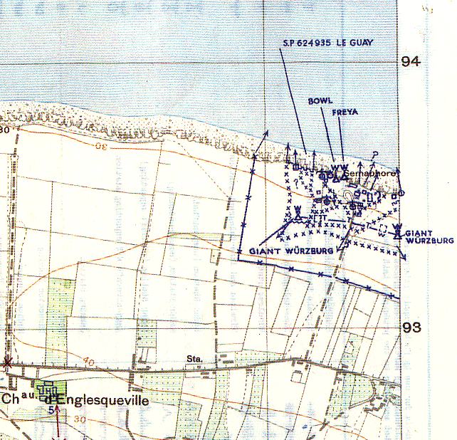
The images of the German radars of Englesqueville can be found on the website "http://omahabeach.vierville.free.fr"
Some images of Englesqueville-la-Percée before the war


(details) Church portal

(details) The cemetery


(details) East Tower of the castle

(details) Isolated tower of the castle, to the south


A visit to the heritage of Englesqueville-la-Percée with the ADTLBRead the rewritten text
This reading version has been rewritten from the newspaper clipping. Connecting phrases and any reconstructed words are not a verbatim quotation.
On Friday, August 29, nearly eighty people participated in a visit to Englesqueville-la-Percée proposed by the Association for the Development of Tourism and Leisure in Bessin, the ADTLB. This latest discovery of the series devoted to the municipalities of Bessin associated built heritage and local history, under the leadership of the association's facilitator.
The article explains the name of the municipality by the low Latin "angliscus", English, the Latin "villa", rural domain, and the place called Pointe de la Percée, on the English Channel. It presents the castle of Englesqueville, also called Saint-Clair, as a 17th century building; Rouge-Fosse as a 16th and 17th century mansion; and Écajeul as a mansion farm of Romanesque origin that has preserved a house with remarkable architectural elements. The church of Saint-Vigor is dated, as a whole, to the end of the 12th and beginning of the 13th centuries.
The visit made it possible to discover some of these buildings and to evoke their guests. The cut cites in particular the stays, in the 19th century, of two presidents of the Republic, Sadi Carnot and Félix Faure. The photograph, credited with Mézerette, shows visitors to the church.
View the archive imageDownload the rewritten text
Original OCR text
The original OCR text is kept for comparison with the image. Its reading order and some words may be incorrect.
A visit to the heritage of Englesqueville-la-Percée with the ADTLBRead the rewritten text
This reading version has been rewritten from the newspaper clipping. Connecting phrases and any reconstructed words are not a verbatim quotation.
On Friday, August 29, nearly eighty people participated in a visit to Englesqueville-la-Percée proposed by the Association for the Development of Tourism and Leisure in Bessin, the ADTLB. This latest discovery of the series devoted to the municipalities of Bessin associated built heritage and local history, under the leadership of the association's facilitator.
The article explains the name of the municipality by the low Latin "angliscus", English, the Latin "villa", rural domain, and the place called Pointe de la Percée, on the English Channel. It presents the castle of Englesqueville, also called Saint-Clair, as a 17th century building; Rouge-Fosse as a 16th and 17th century mansion; and Écajeul as a mansion farm of Romanesque origin that has preserved a house with remarkable architectural elements. The church of Saint-Vigor is dated, as a whole, to the end of the 12th and beginning of the 13th centuries.
The visit made it possible to discover some of these buildings and to evoke their guests. The cut cites in particular the stays, in the 19th century, of two presidents of the Republic, Sadi Carnot and Félix Faure. The photograph, credited with Mézerette, shows visitors to the church.
View the archive imageDownload the rewritten text
Original OCR text
The original OCR text is kept for comparison with the image. Its reading order and some words may be incorrect.
The castle of Englesqueville


(details) Castle facade

(details) Castle gate

La Rougefosse, 2014


Some images of the Semaphore of Englesqueville-la-Percée before the war

The former semaphore, Depillion model, still in service in 1937, armed by 2 naval officers of the National Navy, housed on site with their families.
The whole was evacuated in late 37 or early 38, following a cliff landslide that raised fears for the stability of the construction. It was the semaphore of Longues-sur-Mer that welcomed the crew of that of Englesqueville


(details) The "dévalou" of the semaphore, before war


(details)Aerial photo of the Percée on April 27, 1944 (from Englesqueville to Vierville)

Photo series of February 18, 1943, between the Percée and the semaphore

(details) the Breakthrough, 1- N°82

(details) The semaphore, 4 - N°85


(details) From the Breakthrough to the semaphore, 5 - N°86


(details) From the Breakthrough to the Semaphore, 6 - N°87

(details) Radars, April 29, 1944

(details) 1955

The plans established by the Allies, before the landing

(details) US card at 1/25000

(Details) The station photographed by the Allies before the landing


(details) US card at 1/12500