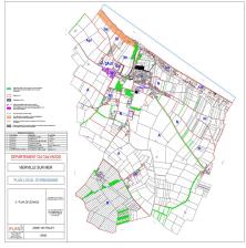
This file brings together descriptions of the landscape and old urban planning documents. They make it possible to understand the shapes of the village, its transformations and the development choices exposed at the time of their writing.
Urbanism, habitat and landscapes
Regulatory zoning
(partly carried out from the PLU survey file)
I - LANDSCAPE ANALYSIS AND HABITAT TYPOLOGY
II - ANALYSIS OF THE BUILDING SPACE
III - REGULATORY URBAN PLANNING AREAS
1 - Great listed site of Omaha Beach, (under the law of 1930)
2 - Remarkable spaces defined in the PLU project
3 - Sensitive natural areas of Calvados
4 - Spaces near the shore (Littoral law)
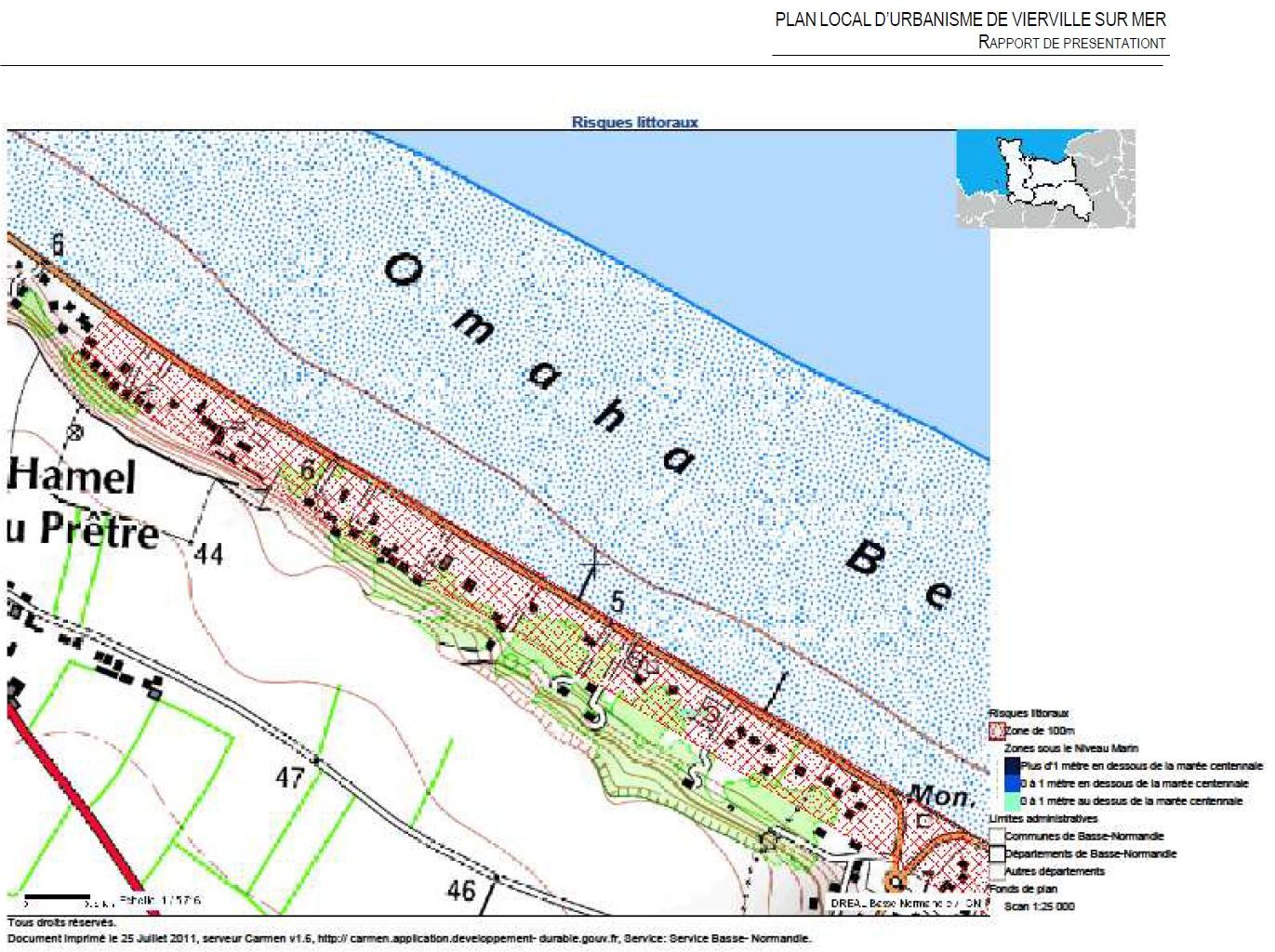
5 - Unbuildable area of 100m (Coastoral law)
6 - Unbuildable area of 100m behind a protective structure (continued Xynthia storm)
7 - Urbanization cuts defined in PLU project
8 - Zoning of the Land Use Plan (POS) in force since 1995
9 - Zoning of the Local Urban Planning Plan (PLU) surveyed in 2011
I - LANDSCAPE ANALYSIS AND HABITAT TYPOLOGY
Since 1993, the "Landscape" law requires urban planning documents to protect and enhance landscapes "remarkable for their landscape interests".
The objective is to identify the different components of the landscape (natural, rural, urban), prioritize them and protect the major elements.
The law goes further, making it possible to protect landscapes that are no longer remarkable but from the structuring elements of our everyday landscapes, we then speak of "identity landscapes" of a territory.
A study was therefore conducted to define the large landscape units, their particularities and constituent elements.
The major landscape entities of Vierville
The municipality is divided into 7 landscape entities, defined on the diagram opposite:
In rural areas:
- in brown, the vertical cliffs
- in orange, the dead cliffs
- in pale green, the agricultural plateau open to the sea, called "the countryside" by locals
- in yellow, the open agricultural plain, i.e. devoid of hedges
- in green, the agricultural space bocager, i.e. partitioned by hedges
In urban space:
- in dark blue, the urbanized "seafront" village
- in gray, the urbanized village "bourg"
He adds to it
- the 4 isolated hamlets: Guerberue, route de Louvières (aux Isles), Vacqueville and Fosse-Taillis
- the 3 places called: Saint-Sever, Vaumicel, l'Ormel
- hisolated habitats
- the camping

- vertical sharp cliffs (brown)
They are located in the northwestern part of the territory, between the municipal limit with Louvières and the urbanized space of the Vierville-sur-Mer waterfront. Abrupt and vertical (30 m), these limestone cliffs overlook the sea and offer magnificent views. They have a variety of biotopes that make them their ecological and landscape value

- the dead cliff (orange)
The waterfront was built below this dead cliff. Like a "link" or a "in between", the hill rises and undulates between the cliffs. A transition element between the plateau and the seafront, it allowed the building to lean against it at the level of the municipalities of Saint-Laurent-sur-Mer and Vierville-sur-Mer.

A rosary of houses is scattered at the foot of the green hill of Vierville-sur-Mer, which is a setting for existing constructions.
The buildings all open to the sea, the location of the building within the plots varying nevertheless: in the heart of the plot for the constructions mainly located to the east of the Monument National Guard or at the bottom of the plot and backed against the hillside for the East fringe near Saint-Laurent-sur-Mer
The seaside architecture of the seafront
The urbanization of the waterfront began at the beginning of the 20th century with, in particular, the development of resorts. The landing of the Allied forces in 1944 completely destroyed the built-up buildings on the seafront. Urbanization at the beginning of the century disappeared (except for 2 villas rebuilt identically) during the German and Allied destruction of 1943 and 1944,
Today the sector is characterized by a reconstruction architecture in rupture with seaside architecture (disproportionate villas, vast plots, art-deco style).
There is thus a certain heterogeneity of the building (shape, height, appearance, materials, etc.). Some constructions play on the monumental side others becoming more discreet (roof terraces, thatched roof,...). The sloping roofs are mainly made of slate. Buildings well inscribed in the landscape because of their architecture (shape and materials) are rare.
However, some terraced or thatched roof houses are almost confused with the dead cliff or the plant.


1st half of the 20th century villa, Norman architecture, identically rebuilt around the pre-war walls

Urbanization extends along the entire length of Boulevard de Cauvigny, up to Saint-Laurent.
This linear urbanization was made on the edge of a wide service road, lined with sidewalks.


Villa with thatched roof

Former Finnish reconstruction shack, recovered and renovated
The houses are very far back from the track (from 10 to 80m), directly at the foot of the cliff.
- the agricultural plateau open to the sea, always called by local people "the countryside", (pale green)
The agricultural plateau open to the sea, located in the maritime part between the cliff and the RD 514, offers a characteristic landscape of crops, open to vast horizons, stretched towards the sky and the sea. Plant structures are rare and only two alignments of pine trees, majestically sculpted by the wind, mark the site.

Seen from the countryside, in the background, the sea horizon
- the open agricultural plain, without hedges (yellow)
The agricultural plain continues this countryside landscape south of the RD 514, with some bocagère hedges on the horizon. Crops are dominant over grass.

- the agricultural space bocager, cut by hedges (dark green)
The space is occupied mainly by crops, but the grasslands are still sometimes seen there (before the war, the crops were non-existent, reserved for "the countryside").
The hinterland is unfolding. The further south we go, the more the hedges structure the agricultural territory. The sea yet very close remains imperceptible.
The hedges structuring the landscape are shrubby with sometimes a few tall trees. The roofs of the buildings punctuate the landscape here and there, inserted in a green setting

- the built village (gray)
The village of Vierville-sur-Mer is a "street village", structured along RD 514 and rue du Hamel-au-Prêtre. Little destroyed at the liberation in 1944 (with the exception of the central crossroads), the village has old buildings from before the war
This old core is characterized by the presence of a building implanted in alignment of lanes (gaw or facade) and on plots originally drawn in strips. Many stone walls structure the track. The originality of the old village is the presence of impasse venelles, courtyards and courtyards. The latter participate in the "breathing" of the urban core and form public spaces (playground for children...).
Of type R+1+attic, the old buildings are made of limestone with mainly slate roofs. Some annexes are composed of tiled roofs. This old building is mostly rehabilitated.
The village of Vierville-sur-Mer has a reconstruction heritage and especially extension that contrasts with the old building.
The development of urbanization took the form of individual housing (pavillon), isolated or in a subdivision (north of the village, rue des ecoles and rue du Mont-Olive).
Located in set back from the alignment, often in the middle of the plot, these pavilions contrast with the old building.
The roofs are mixed, either in slates or tiles.
Public spaces (squares, streets) are minerals. The public buildings, rebuilt, are made of exposed stone, covered with tiles

(details)Rue Pavée, notice the old walls of fences in front of the facades


In the center left, rue Pavée, old
At the top and right, the new district of Écoles and MontOlive streets
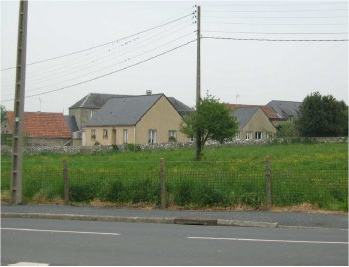


II - THE ANALYSIS OF THE BUILDING SPACE
Definition of the different built entities, pursuant to the Coastal Law of January 3, 1986
The terms "agglomeration", "village", "hamlet", "new hamlet integrated into the environment" are concepts defined by the "Littoral" law and its application documents. The application of this law in the Vierville PLU leads to recall these definitions, because a municipality like Vierville is composed of one or more villages and several hamlets.
The Urban Planning Code specifies that "the extension of urbanization must be carried out either in continuity with existing agglomerations and villages, or in new hamlets integrated into the environment"
The definition of the terms "hamlet", "village", "agglomeration" and "new integrated hamlet", leads to a
distribution of built-in spaces in the municipality of Vierville-sur-Mer which distinguishes within the meaning of the Coastal Law, 2 villages (the village and the seafront), 4 hamlets, isolated places and houses.
Definition of terms
- the "village" is more important than the hamlet. It contains or has contained in the past administrative, religious or commercial collective equipment or places, even if, in some cases, this equipment is no longer necessary
- the "hamlet" is a small group of dwellings - a dozen or fifteen constructions at most -, which may also include other constructions, isolated or separate from the village or village. In existing hamlets, the PLU authorizes the construction of some constructions, inside or at the fringe of the hamlet, provided that the implantation of these constructions does not call into question the relatively modest size of the hamlet.
- the "agglomeration" targets all urbanizations of a larger size or of a different nature.
- the "new hamlet integrated into the environment" brings together grouped constructions, for use as housing, activities or services. It can be built, either in a blank site, or in continuity with one or more existing constructions, while ensuring its proper insertion. Vierville does not provide for such groupings in its PLU.
- There are also in the municipality of Vierville "lieu-dits" built and "isolated housing" of hamlets, villages, agglomerations.

Distribution of villages, hamlets and places in Vierville.
There are no agglomerations or new hamlets
The 2 "villages" of Vierville, the village and the waterfront
The municipality being touristy, there are few shops open all year round (a grocery store-brechery-bakery and a mini market on Mondays), most are open only in tourist season. The inhabitants of the municipality go to Trévières or Bayeux to do their shopping. There is currently no project to expand the commercial fabric. However, could reopen (at least during the tourist season) a drinking establishment in the village and a creperie by the sea.
The village of Vierville-sur-Mer is a "village" that is mainly structured around the RD 514 (East-West axis).
It is characterized in the East by an old urban fabric, rather dense, (rue Pavée and rue du Hamel-au-Prêtre) which has been quite commercial in the past, with public buildings (town hall, school, post office, destroyed in 1944, rebuilt around 1955) and modern houses built since the 1960s in extensions north of the village (new streets des Ecoles and Mont-Olive).
But the village includes another pole to the West, connected by the Château de Vierville (17th century) and its former commons, a pole including several old farmhouses (farms of Normanville, Crespigny, ex-Dubois, ex-Lapersonne, and the D-DAY OMAHA museum.
,
Public services and facilities (town hall, municipal post office, library in the town hall, intermunicipal leisure center, etc.) are located in the village, except for the party room.
It should be noted that the premises of the town hall are not adapted to accommodate people with disabilities.
The municipality no longer has a school. Children are educated in neighboring cities, mainly Trévières and Bayeux

The "village" with its 2 blocks connected by the castle.
The RD 514 that crosses the town from East to West serves as the main street. The majority of the town's streets have sidewalks, allowing pedestrians to move safely.
These pedestrian connections make it possible to connect the various facilities and shops of the village.
The upcoming development of a coastal path, developed by the General Council, will complete the network of soft links existing in the village, especially in its western part.


The waterfront is an elongated seaside village, with less than 100 buildings, hotels, restaurants and villas
The urbanization of the waterfront began at the beginning of the century with, in particular, the development of rail transport. Vierville-sur-Mer has become a resort.
The landing of the Allied forces in 1944 led to the total destruction of the constructions built by the sea.
Today the sector is characterized by an architecture of reconstruction and extensions in rupture with pre-war seaside architecture (disproportionate villas, vast plots, art deco or Norman style).
There is now a great heterogeneity of the building (shape, height, appearance, materials, etc.).
Urbanization now extends over the entire beach and up to the communal boundary with Saint-Laurent-sur-Mer (about 60 to 65 houses on the seafront today while before the war, the villas were fewer - 30 to 35 - and left large unbuilt spaces.
Shops are installed at the bottom of the valley, near the memorials.
A communal festival hall is on the seafront
A mobile rescue station opens in season in front of the sea.

The "seafront" village is served by the RD517 (the boulevard de Cauvigny in the direction of Saint-Laurent-sur-Mer) and the new avenue de Bedford that connects it to the village with the old rue de la mer, which has become both pedestrian and local house service.
The parking areas will be redeveloped there (project of the Community of Municipalities, responsible for roads). There are 75 to 80% of second homes in this sector, which comes alive especially in summer.

The beginning of Boulevard de Cauvigny, to the West

The central part of the boulevard
The 4 identified hamlets of Vierville
Apart from that of Guerberue (the only one in recent extension), the hamlets of the municipality are characterized by the dominant presence of old buildings. They are along public roads and include about 7 to 10 homes.
The hamlets live in connection with the village and local services throughout the year.
The hamlet of Guerberue is located south of the village from which it is separated by a green cut (wood of the castle and Than's mansion). This sector is composed mostly of contemporary buildings (1960s – 2000s). But it already existed in past centuries, including school in the 18th century.
A subdivision of about ten houses has been authorized and the whole has been completed in recent years, leading to a hamlet of about forty recent houses, main or secondary residences. The urban fabric remains loose, structured along small narrow streets, inaccessible to buses.

Hamlet of Guerberue, former hamlet attested in 1694 (see below)

Guerberue today
The hamlet of the Louvières road (in the Isles)
It developed around an old farm, called the Laronche farm, and alonga very old path from the church to the North (founded in the 11th century) to the castle of Saint Sever (18th century), via the crossroads of the Croix-Mitard. This important crossroads led to Formigny to the Southeast and Louvières to the East.
This path also passed through the neighborhood of various important and ancient places, from North to South, the mansion of Than (18th century), the Vaumicel (16th century), l'Ormel (late 16th century), the farm and the castle (18th century) of the Isles.

Hamlet on the Louvières road, near the place called Les Isles

Louvières Road,
At the bottom the old Laronche farm, to the left of the modern houses main residences built with gardens.
The hamlet of Vacqueville is made up of buildings located south of the small road of Vacqueville, around a former large farm, called Vacqueville.
The old building is directly implanted along the track (gable or perimeter walls) with a NO/SE orientation.
A recent house in the hamlet (year 70) is located at the bottom of a courtyard.

Hamlet of Vacqueville

Vacqueville
The hamlet of Fosses-Taillis
(On the road to Saint-Laurent just before entering the village of Saint-Laurent)
There are some main and secondary residences including the buildings of 2 former farms (farm Olard and farm Porée) transformed into residences
A shop for recovered military equipment was established there in 2009.


Fosses Taillis, hamlet built around 2 old farms
In addition, there is dispersed habitat on the municipal territory that corresponds neither to the hamlet name nor to the village appellation within the meaning of the Coastal Law. These are mainly old farmhouses, scattered housing, and camping.
The origin of this dispersed habitat model is certainly the possibility, when the first human installations were created a long time ago, of installing them as close as possible to the fields to be cultivated, water being always available at very shallow depth.
In Vierville, we can note for example the large South district (outside the village) which contains, with the hamlets (Guerberue, the Isles, Vacqueville), the Vaumicel castle, the mansion of Than, the Ormel farm, the castle of Saint-Sever, the Isles farm, not to mention a few more or less isolated houses.
It is a mixed sector composed of both old and recent buildings. The old building of very high quality is part of a setting of vegetation that integrates it into the landscape. This district has no visual relationship with the village. Only the church bell tower is a point of call in the landscape.
III - HISTORICAL AND LANDSCAPE HERITAGE
1 - Historical monuments classified protected by perimeters
Monuments are inseparable from the space that surrounds them: any modification on it reflects on the perception and therefore the conservation of them. Also the law imposes, by a classification and an easement, a right of inspection of the Architect of Buildings of France (ABF) on any modification envisaged within a perimeter of protection of 500 meters of radius around historical monuments.
The notion of "co-visibility" with the monument is decisive here, it is a question of knowing whether the base ground of the project and the monument are either visible from each other or visible together from any point. If there is "co-visibility", the ABF has the right to give a compliant and binding opinion. Otherwise, his opinion is said to be simple and not binding.
Opposite the plan of easements around the classified works in Vierville, from N to South,
- the bell tower of thechurch (October 1, 1913),
- the castle of Vaumicel (June 15, 1927),
- the bell tower of Louvières (classified from 1840) whose perimeter overflows over the territory of Vierville.

The 3 protected perimeters

The Vaumicel, historical monument, a castle of the 16th century, protected by an old enclosure of the Middle Ages
"From a distance, the Vaumicel castle is an impenetrable enclosure.
The agricultural buildings in the foreground form an perimeter line that allows to perceive the castle located in the background (NO/SE oriented with a very slight inclination).
Pety hedges frame the whole and some tree punctuations come to settle the building.
From the Vaumicel road we approach the castle which can be revealed in some places. Part of the park, as well as the grassing at the foot of the walls or the ruins, thus contribute to the pleasure of the public space". (extract from the PLU investigation file)

(details) The church of Vierville, with a historic monument bell tower
_________________

The church of Louvières and its protected bell tower
2 - The historical heritage of 1944, not protected as historical monuments
Places related to History have a variable interest, the quality of the places (for example, emotional power and evocation of the events of June 6, 1944) and their ease of access constituting two determining factors for the use of the site. From these criteria, we distinguish a whole gradient of tourist attendance of the place, ranging from the "minute" stop (the National Guard monument), or even the "second" stop (the commemorative stele of the 1st American cemetery).
There are two types of monuments distributed over the site, each of them generating a different apprehension: (see the chapter 1300-Commemorative Monuments)
- memorials, quite numerous, between 12 and 20, of different types
- remains "witness elements". In particular the remaining fortifications of the German fortified points (WN73, WN72, WN71, WN70) and the remains of the Mulberry artificial port (stranded pontoon in front of Vierville, emerging wrecks at sea, floating walkways exposed along Bedford Avenue)

Red: WN 73, 72, 71
Blue: American pontoon
Orange: F: Monument National Guard
G: Monument 29th division + plaque 5th Battalion of Rangers
H: Monument 6th Engineer Special Brigade
M: DDAY OMAHA museum
3 - Architectural and archaeological sites not protected as historical monuments, but protected under the "Landscape" law. These sites grouped here in 9 groups (9 sketches opposite) are noted in purple on the PLU zoning. We must add the hiking routes to be saved in the same way:
- L'Ormel (16th century mansion), 5 old buildings and 5 walls
- the entire old sector of the Grandcamp road, around the manor farm of Crespigny (16th century, including interior fireplace and facade dovecote). Renovated in 2010
- The whole of the Château de Vierville (17th century, built on numerous remains of the Middle Ages) and the manor of Than (18th century): the castle and many fence walls.
- The château de Saint-Sever (18th century), many old buildings
- the 2 covered wells of Vacqueville
- the covered well south of the Vaumicel and the East perimeter wall
- the well covered in the hamlet of Guerberue
- The 3 covered wells of the hamlet of Fosses-Taillis
- the covered well of rue du Hamel-au-Prêtre

Hamel au Prêtre, 1 covered well to be saved under the Landscape Law

(details) the covered well of the Hamel to the Priests

Fosses-Taillis: 3 wells to be saved for landscapes
Hiking itineraries to preserve

In purple, the itineraries that the PLU plans to save under the Landscape Act
L'Ormel, late 16th century mansion farm

The municipality of Vierville-sur-Mer has several manor farms, typical of Bessin. These stone farmhouses are organized around a square courtyard closed by the buildings of blind farms on the outside and high walls that protect from the eye. (see diagram above)

At the Ormel, 5 buildings and 5 walls to be saved as landscapes

details The old manoir de Crespigny restored in 2007 is part of the sector to be safeguarded of the Grandcamp road (below) under the landscape


Crespigny, the old building body, with the facade dovecotee, before the 2007 renovation

(details) The Vierville Castle

Domains of the Château de Vierville and the mansion of Than: 1 building (castle) and 5 walls to be saved along the Chasse au Fresne and Chasse-Bertin roads, as a landscape

Where 8 buildings are to be safeguarded as landscapes

The place called "Saint-Sever is an impenetrable enclosure.
The built whole (a farmhouse at first glance) is well inscribed in the landscape thanks to the plant
(alleys, hedges, park, grove) which sometimes settles the constructions, sometimes frames the whole.
However, we may regret the planting of conifers that are "foreign" to the local landscape.
From the traffic lanes, the presence of the bourgeois residence is unsuspected. Indeed, this one
is "protected" by the farm and its park. The house is oriented SO/NE.
The park has different landscape elements: a pond, alleys (of chestnut trees in particular),
groves and a French garden featuring the south facade of the bourgeois house." (extract from the PLU investigation file)
__________________________________

Vacqueville: 2 wells to be saved, as landscapes
Vaumicel: 1 well and 1 wall to be saved as landscapes
Guerberue: 1 well to be saved as landscapes
4 - The small built heritage of historical or landscape interest but not provided for on the PLU as to be safeguarded under the Landscape Act.
These are small scattered elements, the classification of which has not been specifically retained, including:
At the Château de Vierville (common):
- a circular dovecote
- a sculpture in the shape of a gargoyle
- the old East enclosure of the Château de Vierville, dating from the Middle Ages, with 1 pointed turret ruined in 1944, 1 low turret, an archer's post
- an old sculpture on a reuse stone in Vacqueville
- a picturesque sculpture (reuse) on a restaurant built around 1880 (la Pie qui Tette)
- An old farm in Les Isles (Blin farm in 1940), opposite
- The old port: remains of the 16th century
- occupation Bronze Age: for the record, finds of remains always possible
- Neolithic occupation: in the peats, especially under the beach, for memory witnesses of the forests of that time

traces of peat exploited in the past, in front of the Vierville dike, a day when the sand was absent, temporarily carried away by the currents.

The'old port dug in the 16th century and abandoned a century later, we can distinguish the edge of the North Quai, made of well-aligned and level cut stones

Château de Vierville, a former dovecote of the Middle Ages, interior

(details) Château de Vierville, a small lookout post with 2 archers

(details) on the commons of the castle of Vierville, a fake stone gargoyle on a very old barn

(details) The East enclosure seen from the North, at the Château de Vierville


5 - Les remarkable wooded areas of Vierville, see page 417
6 - Protected natural heritage
On the rocky edge as well as on the dune and the marsh, the ZNIEFF inventory has highlighted a great botanical variety with the presence of rare species.
On the ornithological level, the cliffs to the east and west of the historic site are a particularly interesting nesting place for seabirds and the thickets welcome many passerines.
Finally, the mosaic of different environments (dune, marsh, thickets, meadows, woods) favors a great diversity of insects.
The following 3 areas were thus included in the classified site of Omaha Beach on the municipal territory of Vierville-sur-Mer:
- a part of the ZNIEFF 1 "cliffs and rocky estrans of the western Bessin"
- part of the Important Bird Conservation Area (ZICO)
- part of the Special Protection Zone included in the network Natura 2000
The inventory of Natural Areas of Wildlife and Floristic Ecological Interest (ZNIEFF) highlighted the ecological qualities of the territory.

Map of sensitive natural environments
These protections attest to a great wealth of heritage. Also, these sectors deserve the name of "remarkable spaces" within the meaning of the "Littoral" law.
IV - REGULATORY URBAN PLANNING AREAS
1 - The "great classified site" of Omaha Beach
This site was classified 2 times, the first time in 1946, under the law of May 2, 1930 on the protection of natural monuments and sites of an artistic, historical, scientific, legendary or picturesque nature. It covered part of the territory of the 3 municipalities, including Vierville-sur-Mer.
A second time on August 23, 2006, under the same law of May 2, 1930 (Article L.341-2 of the Environmental Code), with a specified and expanded perimeter.
The site now integrates the landscape space open to the edge of the plateau to reach and along the limit of the urban areas of the village by encompassing the top of the valley of Vierville-sur-Mer to the RD 514. To the southeast of the village, it resumes the limit of the open agricultural space and leans on the limits of the bocage to the urban space of the village of Saint-Laurent-sur-Mer, which it follows, however, integrating the bottom of the plots of Rue du Val.
To ensure the maintenance of the quality of the premises, work likely to modify the appearance of the premises is subject to special authorization and therefore the agreement of the competent Minister after the advice of the Site Commission
Normal maintenance and operation work that does not result in alteration of the site is authorized.

The "Grand Site of Omaha Beach"
(Territory of Vierville-sur-Mer)
Are prohibited in fact:
- the practice of camping outside the authorized fields,
- the parking of caravans even for less than three months, mobile homes and the development of land to receive this type of accommodation. Any derogation from this prohibition may only be granted by the competent minister after consulting the site commission,
- display and advertising
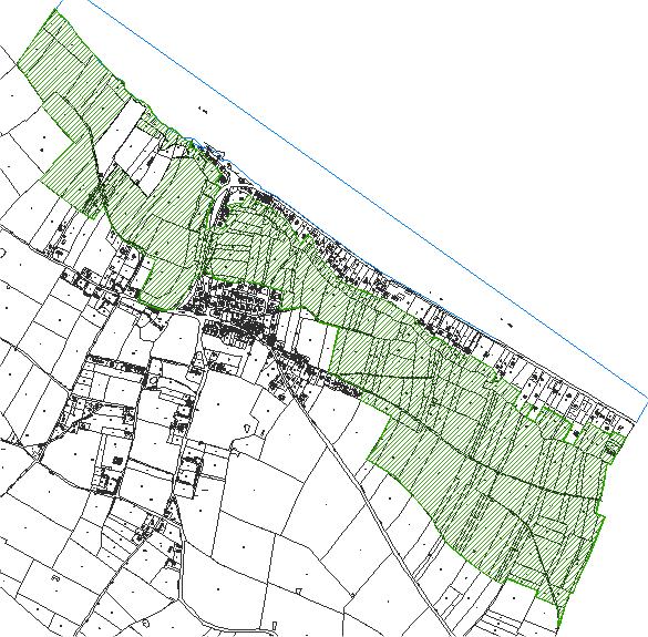
2 - The "remarkable spaces" of Vierville
The Local Urban Planning Plans (Article L146-6 and R146-6 of the Urban Planning Code) "preserve terrestrial and marine spaces, remarkable or characteristic sites and landscapes of the natural and cultural heritage of the coast, and the environments necessary to maintain biological balances"
On the other hand, the natural parts of the sites registered or classified pursuant to the law of May 2, 1930 are preserved as such.
On the municipal territory of Vierville-sur-Mer, the Remarkable Spaces correspond to:
- to the natural areas of the site of Omaha Beach, listed as a classified site
(Under the law of May 2, 1930),
- to the cliffs and rocky estrans of the western Bessin (ZNIEFF type 1),
- to the important area for the conservation of birds (ZICO), also identified as a special protection zone (ZPS) and included in the Natura 2000 network.
The spaces occupied by the existing campsite as well as some urbanized spaces of the village, are not classified as remarkable spaces, even if they are part of the classified site.
Remarkable spaces of Vierville-sur-Mer
3 - The sensitive natural areas of Vierville
In 1977, the Department of Calvados was committed to a policy in favor of the sensitive natural areas of its territory. The law does not give a definition of the concept of sensitivity, the Department of Calvados has thus based its policy on ecological, landscape and social criteria allowing a wide range of sites to be included
In this policy.
In 2003, 24 pre-emption perimeters were created as such, one of which concerns the Omaha Beach site.
The Department has delegated its right of pre-emption on the Omaha Beach site to the Conservatoire du Littoral under Sensitive Natural Areas.

The sensitive site of Omaha Beach, as it appears to have been defined in 2003
4 - Areas close to the shore in Vierville (application of the "coastal" law)
In the PLU, the limited extension of the urbanization of areas close to the shore must be justified and motivated, according to criteria related to the configuration of the premises and the reception of economic activities requiring the immediate proximity of water.
On the territory of Vierville-sur-Mer, the main criteria that make it possible to define a limit of the Areas Close to the Shores are:
- the topography of the places and visibility on the coast.
The municipal territory is characterized by the existence of a plateau and cliffs, vertical and rectilinear (about thirty meters) on the west facade of the coast, a dead cliff, in the east part of the coast; these two entities being separated by a valley, a coastal depression corresponding to the seafront and the beach. The RD 514, located on the plateau, marks the ridge line. Views of the coastline are possible from this road.
- the proximity to the coastline (kilometer distance between the shore and the interior),
-land use
The main activity of the territory remains agricultural activity. Thus, the plots are essentially dedicated to agriculture: presence of crops and pastures except on the dead cliff. The present culture is not particularly typical of seasides.
- the coastal atmosphere (particular landscape entity related to land use, vegetation, the impact of the visible climate on the appearance of vegetation, a particular geology, etc.).
There are few hedges north of RD 514. There are typical species of the seaside and fields open to vast horizons, stretched towards the sky and the sea. Plant structures are rare and only two alignments of pine trees, sculpted by the wind, mark the site.
Delimitation of "spaces close to the shore"
As part of the development of the Bessin SCOT, a limit of "spaces close to the shore" was defined and reported on the protection map of the SCOT General Guidance Document.
In the municipality of Vierville-sur-Mer, this limit of "spaces close to the shore" is mainly based on the proximity of the coast and on the topography of the place, that is to say between the edge of the plateau and the roads RD 514 and Chemin du Hamel au Prêtre.
5 - The 100-meter strip in Vierville (application of the "coastal" law)
The strip of 100 meters from the shore is unbuildable, outside of urbanized spaces.
An exception is made only if they are constructions or installations necessary for public services or economic activities requiring the immediate proximity of water
This 100-meter strip appears on the zoning plan. It is calculated from the upper limit of the shore. On this zoning plan, only the part west of the valley is shown, unlike the attached plan extracted from the PLU survey. At the time of writing, Yves Cordelle considered it likely that this zoning plan would be retained after the investigation then underway.

The 100m unbuildable strip
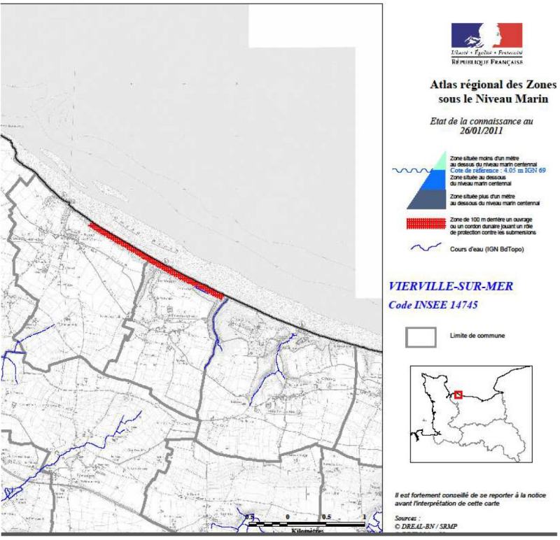
6 - The unbuildable area of 100 meters behind the protective dike, established following the storms of 2008 and February 2010 (Xynthia).
The prohibited construction zone begins to the west with lots AB301-302 (Coffignal properties) and extends to the Saint-Laurent border, on the Ua and Ub zones of the PLU.
The designers had to consider that the lots further west were well above the level of the centenary tide. In particular, it seems that all the spaces behind the dike are in fact filled in.
The conditions of application are in principle: (PLU, zone regulations Ua and Ub, article U2) "in the sector called "area of 100m behind a structure or dune cordon" only the developments of the existing, the extensions measured without increasing the ground clearance and the annexes are authorized subject to not increasing the capacity of people in the face of the risk of submersion"
See also the applicable circulars, cited in chapter 10 in fine.

The protection zone, with the map at 1/25000 as a plan background.

The protection area, with photographic plan background

7 - Urbanization cuts in Vierville
The municipal territory of Vierville-sur-Mer has five distinct semi-natural spaces with the characteristics of an "urbanization cut"
These are the following 5 cut-off spaces (figured in green on the diagram opposite):
- between the built waterfront and the unbuilt coastal fringe to the west of the beach, corresponding to the cliffs and rocky estrans of Bessin, in communal limit with Louvières over a length of 700 meters,
- in the agricultural area located between the village and the built waterfront.
- in a natural space, materialized by meadows, separating the village from the church and more broadly from the neighborhoods south of the village, church, Guerberue, Vaumicel, les Isles.
- agricultural areas located to the west of the village.
- agricultural areas located to the west of the village.
The objective is to reduce urban sprawl along the RD 514 by favoring urbanization within and on the edge of urban space.

Urbanization cuts
8 - Zoning of the old Land Use Plan of 1995